File:Buir Nuur in Eastern Mongolia and in China (Inner Mongolia), LandSat-7 2005-08-9.png

本预览的尺寸:531 × 599像素。 其他分辨率:213 × 240像素 | 426 × 480像素 | 681 × 768像素 | 908 × 1,024像素 | 1,642 × 1,852像素。
原始文件 (1,642 × 1,852像素,文件大小:4.83 MB,MIME类型:image/png)
,_LandSat-7_2005-08-9.png?uselang=zh-cn)
,_LandSat-7_2005-08-9.png?uselang=zh-cn)
,_LandSat-7_2005-08-9.png?action=history&uselang=zh-cn)
,_LandSat-7_2005-08-9.png)
摘要
| 描述 |
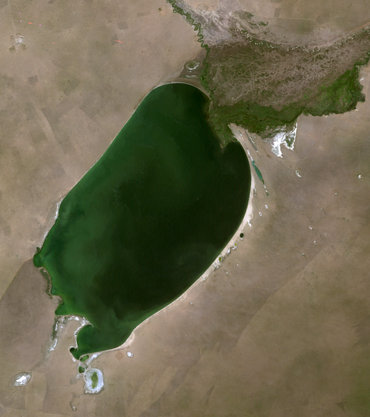
English: Buir Nuur lake in Eastern Mongolia (Dornod province) and in China (Inner Mongolia), LandSat-7 satellite image, 2005-08-9, near natural colors, 30 m resolution |
| 日期 | |
| 来源 | http://edcsns17.cr.usgs.gov/NewEarthExplorer/ |
| 作者 | NASA |
许可协议
| 本文件完全由NASA创作,在美国属于公有领域。根据NASA的版权方针,NASA的材料除非另有声明否则不受版权保护。(参见Template:PD-USGov/zh、NASA版权方针页面或JPL图片使用方针。) | ||
 |
警告:
|
文件历史
点击某个日期/时间查看对应时刻的文件。
| 日期/时间 | 缩略图 | 大小 | 用户 | 备注 | |
|---|---|---|---|---|---|
| 当前 | 2010年11月1日 (一) 17:32 | | 1,642 × 1,852(4.83 MB) | Bogomolov.PL | {{Information |Description={{en|1=Buir Nuur lake in Eastern Mongolia (Dornod province) and in China (Inner Mongolia), LandSat-7 satellite image, 2005-08-9, near natural colors, 30 m resolution}} |Source=http://edcsns17.cr.usgs.gov/NewEarthExplorer/ |Autho |
文件用途
全域文件用途
以下其他wiki使用此文件:
- arz.wikipedia.org上的用途
- bg.wikipedia.org上的用途
- cs.wikipedia.org上的用途
- cv.wikipedia.org上的用途
- de.wikipedia.org上的用途
- en.wikipedia.org上的用途
- es.wikipedia.org上的用途
- fa.wikipedia.org上的用途
- fi.wikipedia.org上的用途
- fr.wikipedia.org上的用途
- hu.wikipedia.org上的用途
- id.wikipedia.org上的用途
- it.wikipedia.org上的用途
- ja.wikipedia.org上的用途
- ko.wikipedia.org上的用途
- lt.wikipedia.org上的用途
- lv.wikipedia.org上的用途
- mn.wikipedia.org上的用途
- pa.wikipedia.org上的用途
- pl.wikipedia.org上的用途
- ru.wikipedia.org上的用途
- tr.wikipedia.org上的用途
- uk.wikipedia.org上的用途
- vi.wikipedia.org上的用途
- www.wikidata.org上的用途
,_LandSat-7_2005-08-9.png)