File:Goa locator map.svg

此SVG文件的PNG预览的大小:274 × 331像素。 其他分辨率:199 × 240像素 | 397 × 480像素 | 636 × 768像素 | 848 × 1,024像素 | 1,695 × 2,048像素。
原始文件 (SVG文件,尺寸为274 × 331像素,文件大小:93 KB)
| 标题 |
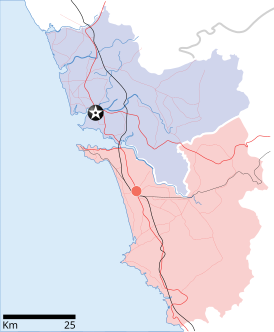
Goa locator map |
| 描写 |
Locator map for the state of w:Goa. Coordinates: top=15.811, bottom=14.861, left=73.567, right=74.287. |
| 日期 | |
| 来源 |
自己的作品 |
| 创作作者 | |
| 授权 (二次使用本文件) |
我,本作品著作权人,特此采用以下许可协议发表本作品: 本文件采用知识共享署名-相同方式共享 3.0 未本地化版本许可协议授权。
|
| Geotemporal data | |
| 描绘日期 | 20世纪下半期和21世纪 |
| 地理参考 | 如果不适当,请设置 warp_status = skip 为隐藏。 |
| Archival data | |
| 备注 | Part of WikiProject India Maps |
文件历史
点击某个日期/时间查看对应时刻的文件。
| 日期/时间 | 缩略图 | 大小 | 用户 | 备注 | |
|---|---|---|---|---|---|
| 当前 | 2007年4月26日 (四) 10:48 | | 274 × 331(93 KB) | Planemad | upd |
| 2007年4月26日 (四) 10:40 |  | 274 × 331(80 KB) | Planemad | upd | |
| 2007年4月9日 (一) 18:27 |  | 274 × 331(66 KB) | Planemad | {{WikiProject_India_Maps |Title=Goa locator map |Description=Locator map for the state of [w:Goa]] |Source= [http://www.bombayproperty.com/goamap.jpg Map of Goa], |Date=April 2007 |Author=w:user:Planemad }} Category:WikiProject India State Maps |
文件用途
以下页面使用本文件:
全域文件用途
以下其他wiki使用此文件:
- ar.wikipedia.org上的用途
- ba.wikipedia.org上的用途
- ceb.wikipedia.org上的用途
- cy.wikipedia.org上的用途
- de.wikipedia.org上的用途
- en.wikipedia.org上的用途
- Farmagudi
- Zuari River
- Pilar, Goa
- Bardez
- Sonsogor
- Flora and fauna of Goa
- Sanguem
- Mollem, Goa
- Dabolim
- Template:Goa-geo-stub
- Aquem
- Bambolim
- Bandora, Goa
- Canacona
- Karapur
- Chicalim
- Chimbel
- Colvale
- Curti, Goa
- Davorlim
- Parcem
- Penha de França, Goa
- Queula
- Sancoale
- Sanquelim
- Sanvordem
- São José de Areal
- Valpoi
- Arpora
- Altinho, Goa
- Mardol, Goa
- Gokarna Math
- Baga, Goa
- Baga Creek
- Chapora Beach
- Terekhol River
- Kasarpal
- Revora
- Pale, Goa
- Agaçaim
- Priol
- Betul, Goa
- Bogmalo
- Adas Bank
- St Inez Creek
查看本文件的更多全域用途。