File:Heartland.png
此为最大尺寸。
Heartland.png (752 × 449像素,文件大小:43 KB,MIME类型:image/png)
摘要
| 描述 |
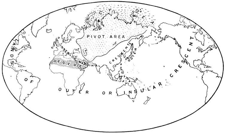
English: A map from Halford Mackinder's The Geographical Pivot of History
Nederlands: Het door Mackinder aangewezen Heartland, ook wel The Geographical Pivot of History genoemd. |
| 日期 | 2006年3月18日 (原始上传日期) |
| 来源 | "The Geographical Pivot of History", Geographical Journal 23, no. 4 (April 1904): 435.. Originally from nl.wikipedia; description page is/was here. |
| 作者 | Halford J. Mackinder |
许可协议
|
本作品在其来源国以及其他著作权期限是作者逝世后70年或以下的国家和地区属于公有领域。 | |
| 本文件已被确认为免除已知的著作权法限制(包括所有相关权利)。 | |
原始上传日志
(All user names refer to nl.wikipedia)
- 2006-03-18 14:47 Marc-king 752×449×8 (65439 bytes) {{Bronvermelding}}
文件历史
点击某个日期/时间查看对应时刻的文件。
| 日期/时间 | 缩略图 | 大小 | 用户 | 备注 | |
|---|---|---|---|---|---|
| 当前 | 2014年2月22日 (六) 16:36 | | 752 × 449(43 KB) | AnonMoos | increasing PNG compression |
| 2010年8月13日 (五) 14:39 |  | 752 × 449(82 KB) | Beao | Transparent. | |
| 2007年2月2日 (五) 14:01 |  | 752 × 449(64 KB) | Siebrand | {{Information |Description={{nl|Het door Mackinder aangewezen Heartland, ook wel The Geographical Pivot of History genoemd.}} |Source="The Geographical Pivot of History", Geographical Journal 23, no. 4 (April 1904): 435.. Originally from [http://nl.wikipe |
文件用途
全域文件用途
以下其他wiki使用此文件:
- ar.wikipedia.org上的用途
- bg.wikipedia.org上的用途
- bs.wikipedia.org上的用途
- cs.wikipedia.org上的用途
- da.wikipedia.org上的用途
- de.wikipedia.org上的用途
- el.wikipedia.org上的用途
- en.wikipedia.org上的用途
- en.wiktionary.org上的用途
- es.wikipedia.org上的用途
- fi.wikipedia.org上的用途
- he.wikipedia.org上的用途
- hi.wikipedia.org上的用途
- hy.wikipedia.org上的用途
- it.wikipedia.org上的用途
- ja.wikipedia.org上的用途
- ka.wikipedia.org上的用途
- nl.wikipedia.org上的用途
- no.wikipedia.org上的用途
- pl.wikipedia.org上的用途
- pt.wikipedia.org上的用途
- ru.wikipedia.org上的用途
- sv.wikipedia.org上的用途
- uk.wikipedia.org上的用途
- www.wikidata.org上的用途