File:MSH82 st helens spirit lake reflection 05-19-82.jpg

本预览的尺寸:800 × 544像素。 其他分辨率:320 × 218像素 | 640 × 435像素 | 1,024 × 697像素 | 1,280 × 871像素 | 2,560 × 1,742像素 | 4,734 × 3,221像素。
原始文件 (4,734 × 3,221像素,文件大小:1.1 MB,MIME类型:image/jpeg)
摘要
| 描述 |
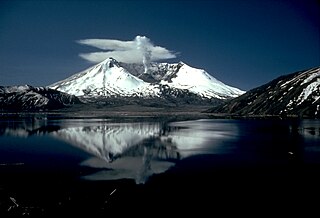
English: Mount St. Helens and the devastated area is now within the 110,000-acre Mount St. Helens National Volcanic Monument, under jurisdiction of the United States Forest Service. Visitor centers, interpretive areas, and trails are being established as thousands of tourists, students, and scientists visit the monument daily. Mount St. Helens is once again considered to be one of the most beautiful and interesting of the Cascade volcanic peaks. |
|||
| 日期 | ||||
| 来源 |
CVO Photo Archives Mount St. Helens, Washington Before, During, and After May 18, 1980 |
|||
| 作者 | Lyn Topinka | |||
| 授权 (二次使用本文件) |
|
文件历史
点击某个日期/时间查看对应时刻的文件。
| 日期/时间 | 缩略图 | 大小 | 用户 | 备注 | |
|---|---|---|---|---|---|
| 当前 | 2007年11月28日 (三) 17:54 | | 4,734 × 3,221(1.1 MB) | CarolSpears | |
| 2005年8月9日 (二) 06:02 |  | 2,935 × 1,996(832 KB) | Complex01 | USGS photo of Mt. Saint Helens. '''Caption''': Mount St. Helens and the devastated area is now within the 110,000-acre Mount St. Helens National Volcanic Monument, under jurisdiction of the United States Forest Service. Visitor centers, interpretive area |
文件用途
以下页面使用本文件:
全域文件用途
以下其他wiki使用此文件:
- ca.wikipedia.org上的用途
- cs.wikipedia.org上的用途
- da.wikipedia.org上的用途
- en.wikipedia.org上的用途
- en.wikivoyage.org上的用途
- eo.wikipedia.org上的用途
- es.wikipedia.org上的用途
- fi.wikipedia.org上的用途
- fr.wikipedia.org上的用途
- fr.wikibooks.org上的用途
- fr.wikiversity.org上的用途
- he.wikipedia.org上的用途
- he.wikivoyage.org上的用途
- hr.wikipedia.org上的用途
- hu.wikipedia.org上的用途
- it.wikipedia.org上的用途
- ja.wikipedia.org上的用途
- no.wikipedia.org上的用途
- ro.wikipedia.org上的用途
- sh.wikipedia.org上的用途
- sk.wikipedia.org上的用途
- sr.wikipedia.org上的用途
- sv.wikipedia.org上的用途
- uk.wikipedia.org上的用途
- www.wikidata.org上的用途