File:Map of Iceland.svg

此SVG文件的PNG预览的大小:739 × 600像素。 其他分辨率:296 × 240像素 | 591 × 480像素 | 946 × 768像素 | 1,261 × 1,024像素 | 2,523 × 2,048像素 | 1,834 × 1,489像素。
原始文件 (SVG文件,尺寸为1,834 × 1,489像素,文件大小:717 KB)
摘要
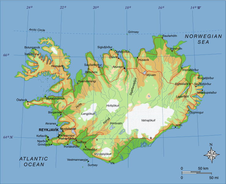
| 描述 | A map of Iceland, showing major towns, rivers, lakes and glaciers. Translated from a map on the Greek Wikipedia (located here). |
| 日期 | |
| 来源 | 自己的作品, based on File:Map of Iceland el.svg created by el:user:Αντιγόνη |
| 作者 | Max Naylor |
许可协议
| 本作品已被作者I, Max Naylor释出到公有领域。这适用于全世界。 在一些国家这可能不合法;如果是这样的话,那么: I, Max Naylor无条件地授予任何人以任何目的使用本作品的权利,除非这些条件是法律规定所必需的。 |
| 注解 | 该图片含有注解:在维基媒体共享资源上查看注解 |
文件历史
点击某个日期/时间查看对应时刻的文件。
| 日期/时间 | 缩略图 | 大小 | 用户 | 备注 | |
|---|---|---|---|---|---|
| 当前 | 2007年6月23日 (六) 19:15 | | 1,834 × 1,489(717 KB) | Max Naylor~commonswiki | == Summary == {{Information |Description=A map of Iceland, showing major towns, rivers, lakes and glaciers. Translated from a map on the Greek Wikipedia ([http://el.wikipedia.org/wiki/Εικόνα:Map_of_Iceland.svg located here]). |Source=self-made |Date |
| 2007年6月23日 (六) 19:11 |  | 1,834 × 1,489(710 KB) | Max Naylor~commonswiki | == Summary == {{Information |Description=A map of Iceland, showing major towns, rivers, lakes and glaciers. Translated from a map on the Greek Wikipedia ([http://el.wikipedia.org/wiki/Εικόνα:Map_of_Iceland.svg located here]). |Source=self-made |Date | |
| 2007年6月23日 (六) 19:07 |  | 1,834 × 1,489(694 KB) | Max Naylor~commonswiki | {{Information |Description=A map of Iceland, showing major towns, rivers, lakes and glaciers. Translated from a map on the Greek Wikipedia ([http://el.wikipedia.org/wiki/Εικόνα:Map_of_Iceland.svg located here]). |Source=self-made |Date=23 June 2007 |
文件用途
以下页面使用本文件:
全域文件用途
以下其他wiki使用此文件:
- af.wikipedia.org上的用途
- ar.wikipedia.org上的用途
- arz.wikipedia.org上的用途
- avk.wikipedia.org上的用途
- azb.wikipedia.org上的用途
- bg.wikipedia.org上的用途
- bn.wikipedia.org上的用途
- co.wikipedia.org上的用途
- cs.wikipedia.org上的用途
- da.wikipedia.org上的用途
- de.wikipedia.org上的用途
- de.wikibooks.org上的用途
- dz.wikipedia.org上的用途
- el.wikipedia.org上的用途
- en.wikipedia.org上的用途
- en.wikibooks.org上的用途
- en.wikiquote.org上的用途
- fa.wikipedia.org上的用途
- fi.wikipedia.org上的用途
- fo.wikipedia.org上的用途
- fr.wikipedia.org上的用途
- gag.wikipedia.org上的用途
- gv.wikipedia.org上的用途
- he.wikipedia.org上的用途
查看本文件的更多全域用途。