File:Sunken Japanese battleship Haruna off Koyo, Etajima (Japan), on 8 October 1945 (80-G-351726).jpg

本预览的尺寸:800 × 526像素。 其他分辨率:320 × 211像素 | 640 × 421像素 | 1,024 × 674像素 | 1,280 × 842像素 | 2,560 × 1,684像素 | 4,632 × 3,047像素。
原始文件 (4,632 × 3,047像素,文件大小:3.7 MB,MIME类型:image/jpeg)
,_on_8_October_1945_(80-G-351726).jpg?uselang=zh-cn)
,_on_8_October_1945_(80-G-351726).jpg?uselang=zh-cn)
,_on_8_October_1945_(80-G-351726).jpg?action=history&uselang=zh-cn)
,_on_8_October_1945_(80-G-351726).jpg)
摘要
| 摄影师 |
未知 |
||||||||||||||||||||
| 描述 |
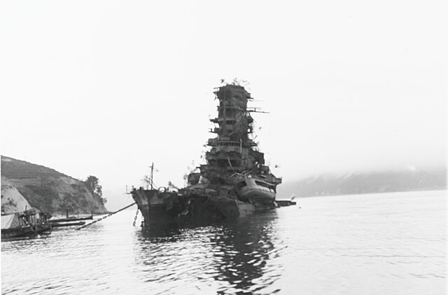
English: The sunken Japanese battleship Haruna off Koyo, Etajima, Japan, on 8 October 1945. She had been sunk by carrier plane attacks on 28 July 1945. Note the small vessel beached on her forecastle, and the tree limbs mounted on her decks and superstructure as a camouflage measure. |
||||||||||||||||||||
| 描绘地点 |
|
||||||||||||||||||||
| 馆藏 |
|
||||||||||||||||||||
| 登录号 |
80-G-351726 |
||||||||||||||||||||
| 来源 | U.S. Navy photo 80-G-351726 | ||||||||||||||||||||
,_on_8_October_1945_(80-G-351726).jpg¶ms=034.251510_N_0132.494040_E_globe:Earth_type:camera__&language=zh-cn)
许可协议
| This image is available from the Naval History and Heritage Command under the digital ID 80-G-351726. Most of the photos found in the NHHC collection are in the public domain and may be downloaded and used without permissions or special requirements. Those which are not will be noted in the copyright section of the NHHC image description.[1] |
 | ||
| 本文件已被确认为免除已知的著作权法限制(包括所有相关权利)。 | ||
文件历史
点击某个日期/时间查看对应时刻的文件。
| 日期/时间 | 缩略图 | 大小 | 用户 | 备注 | |
|---|---|---|---|---|---|
| 当前 | 2023年12月6日 (三) 17:41 | | 4,632 × 3,047(3.7 MB) | Meeepmep | Brightness |
| 2023年12月4日 (一) 18:22 |  | 4,632 × 3,047(4.38 MB) | Meeepmep | Better quality | |
| 2023年11月16日 (四) 21:21 |  | 4,520 × 2,691(2.33 MB) | Meeepmep | Cropped < 1 % horizontally, 20 % vertically using CropTool with lossless mode. | |
| 2018年9月15日 (六) 11:08 |  | 4,526 × 3,356(2.78 MB) | Cobatfor | high-res file | |
| 2007年3月24日 (六) 22:22 |  | 610 × 741(50 KB) | Editor at Large | Losslessly cropped caption bar | |
| 2005年7月18日 (一) 21:47 |  | 610 × 765(54 KB) | Lzz~commonswiki | Japanese battleship Haruna sunk at Kure ,Oct. 1945 {{PD-USGov-Military-Navy}} Source [http://www.history.navy.mil/photos/images/g350000/g351726.jpg] |
文件用途
全域文件用途
以下其他wiki使用此文件:
- ar.wikipedia.org上的用途
- arz.wikipedia.org上的用途
- ast.wikipedia.org上的用途
- bg.wikipedia.org上的用途
- bjn.wikipedia.org上的用途
- cs.wikipedia.org上的用途
- da.wikipedia.org上的用途
- de.wikipedia.org上的用途
- en.wikipedia.org上的用途
- es.wikipedia.org上的用途
- fr.wikipedia.org上的用途
- he.wikipedia.org上的用途
- hu.wikipedia.org上的用途
- id.wikipedia.org上的用途
- it.wikipedia.org上的用途
- ja.wikipedia.org上的用途
- ka.wikipedia.org上的用途
- ms.wikipedia.org上的用途
- nl.wikipedia.org上的用途
- pl.wikipedia.org上的用途
- pt.wikipedia.org上的用途
- ro.wikipedia.org上的用途
- ru.wikipedia.org上的用途
- sh.wikipedia.org上的用途
- sk.wikipedia.org上的用途
- sr.wikipedia.org上的用途
- sv.wikipedia.org上的用途
- th.wikipedia.org上的用途
- uk.wikipedia.org上的用途
- vi.wikipedia.org上的用途
,_on_8_October_1945_(80-G-351726).jpg)