File:Topographic map of Liberia-en.svg

此SVG文件的PNG预览的大小:799 × 600像素。 其他分辨率:320 × 240像素 | 640 × 480像素 | 1,023 × 768像素 | 1,280 × 961像素 | 2,560 × 1,922像素 | 3,148 × 2,363像素。
原始文件 (SVG文件,尺寸为3,148 × 2,363像素,文件大小:1.69 MB)
摘要
| 描述 |
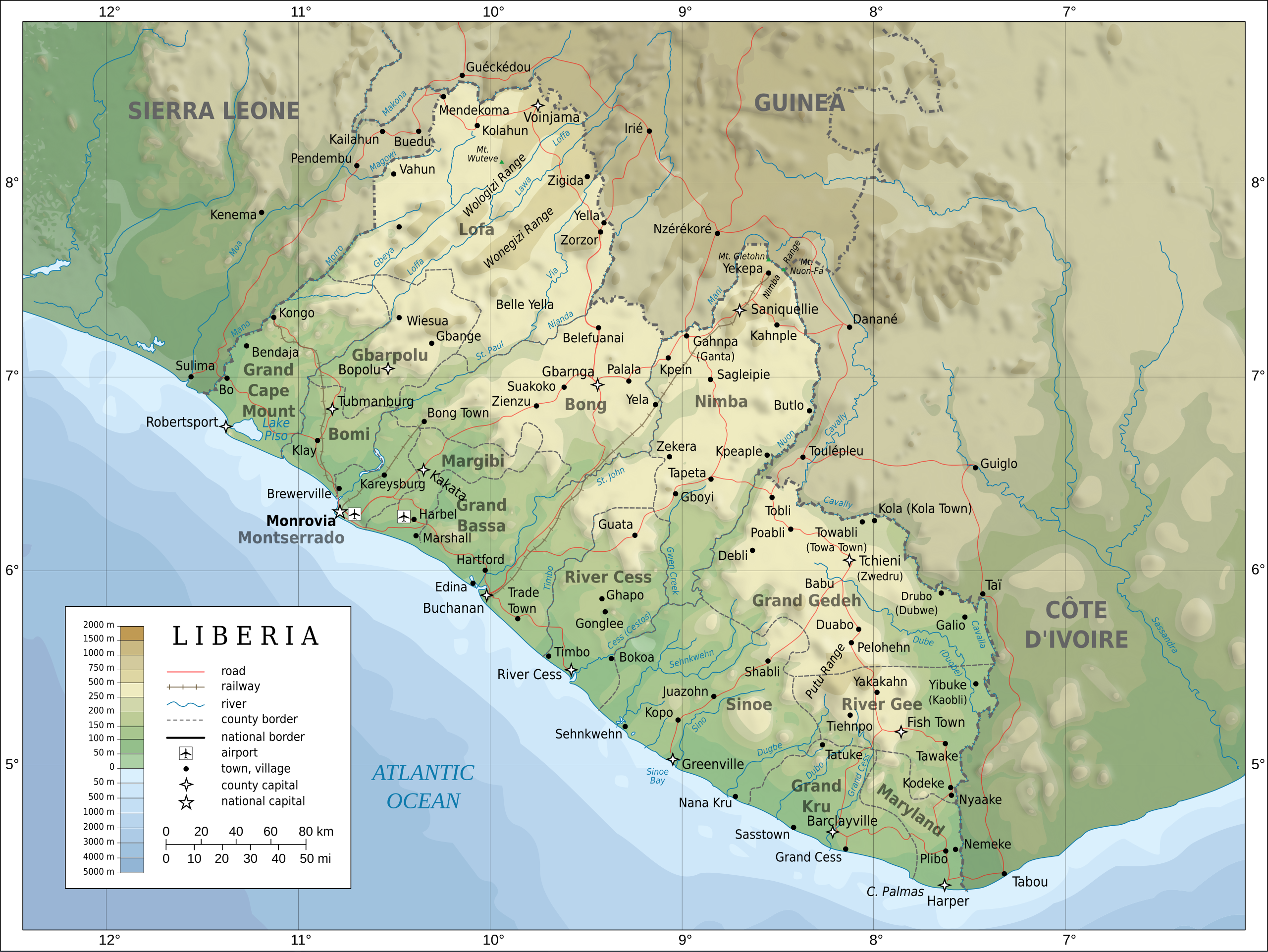
English: Topographic map of Liberia.
Français : Carte topographique du Liberia.
Suomi: Liberian topografinen kartta. |
| 日期 | |
| 来源 |
Self-made in Inkscape. Boundaries, rivers, roads, railroads, and place names based on a public domain United Nations map (Image:Un-liberia.png). Topography based on public domain GLOBE data from NOAA (http://www.ngdc.noaa.gov/mgg/topo/gltiles.html). Relief shading is an embedded PNG raster, derived from the GLOBE data using Perl. Bathymetry from NGDC ETOPO2. |
| 作者 | Oona Räisänen (Mysid) |
| 其他版本 |
此文件衍生的作品: Railways in liberia-de.svg
|


|
此SVG檔案包含可翻譯至您的語言的内嵌文字,可以使用任何可用SVG編輯器、文本編輯器或SVG翻譯工具來翻譯。詳情請見:關於翻譯SVG檔案。 |
许可协议
我,本作品著作权人,特此采用以下许可协议发表本作品:

|
已授权您依据自由软件基金会发行的无固定段落及封面封底文字(Invariant Sections, Front-Cover Texts, and Back-Cover Texts)的GNU自由文件许可协议1.2版或任意后续版本的条款,复制、传播和/或修改本文件。该协议的副本请见“GNU Free Documentation License”。 |
This file is licensed under the Creative Commons Attribution-Share Alike 4.0 International, 3.0 Unported, 2.5 Generic, 2.0 Generic and 1.0 Generic license.
- 您可以自由地:
- 共享 – 复制、发行并传播本作品
- 修改 – 改编作品
- 惟须遵守下列条件:
- 署名 – 您必须对作品进行署名,提供授权条款的链接,并说明是否对原始内容进行了更改。您可以用任何合理的方式来署名,但不得以任何方式表明许可人认可您或您的使用。
- 相同方式共享 – 如果您再混合、转换或者基于本作品进行创作,您必须以与原先许可协议相同或相兼容的许可协议分发您贡献的作品。
您可以选择您需要的许可协议。
文件历史
点击某个日期/时间查看对应时刻的文件。
| 日期/时间 | 缩略图 | 大小 | 用户 | 备注 | |
|---|---|---|---|---|---|
| 当前 | 2010年7月31日 (六) 20:08 | | 3,148 × 2,363(1.69 MB) | Mysid | remove the false "dropoff" from land to sea in shading |
| 2010年7月31日 (六) 20:02 |  | 3,148 × 2,363(1.69 MB) | Mysid | fixed a couple of symbols + clipped the shading layer | |
| 2010年7月19日 (一) 10:49 |  | 3,148 × 2,363(2.64 MB) | Mysid | argh, forgot to update legend box | |
| 2010年7月19日 (一) 10:41 |  | 3,148 × 2,363(2.64 MB) | Mysid | revised for consistency with my other maps | |
| 2008年5月25日 (日) 12:46 |  | 3,148 × 2,363(2.87 MB) | Mysid | border in image; layers in XML | |
| 2008年5月12日 (一) 18:34 |  | 3,037 × 2,257(2.82 MB) | Mysid | adding lakes, airports, legends | |
| 2008年5月12日 (一) 16:44 |  | 3,037 × 2,257(2.81 MB) | Mysid | == {{int:filedesc}} == {{Information |Description= {{en|Topographic map of Liberia.}} {{fr|Carte topographique du Liberia.}} {{fi|Liberian topografinen kartta.}} |Source=Self-made in Inkscape.<br/>Boundaries |
文件用途
以下3个页面使用本文件:
全域文件用途
以下其他wiki使用此文件:
- ar.wikipedia.org上的用途
- az.wikipedia.org上的用途
- bcl.wikipedia.org上的用途
- be-tarask.wikipedia.org上的用途
- be.wikipedia.org上的用途
- bn.wikipedia.org上的用途
- ca.wikipedia.org上的用途
- ckb.wikipedia.org上的用途
- de.wikipedia.org上的用途
- el.wikipedia.org上的用途
- en.wikipedia.org上的用途
- eu.wikipedia.org上的用途
- fa.wikipedia.org上的用途
- fi.wikipedia.org上的用途
- fr.wikipedia.org上的用途
- hr.wiktionary.org上的用途
- hu.wikipedia.org上的用途
- hy.wikipedia.org上的用途
- id.wikipedia.org上的用途
- io.wikipedia.org上的用途
- is.wikipedia.org上的用途
- it.wikipedia.org上的用途
- ka.wikipedia.org上的用途
- lt.wikipedia.org上的用途
- mzn.wikipedia.org上的用途
- nds.wikipedia.org上的用途
- nl.wikipedia.org上的用途
- pl.wikipedia.org上的用途
- ps.wikipedia.org上的用途
查看本文件的更多全域用途。