File:Topography of africa.jpg

本预览的尺寸:548 × 599像素。 其他分辨率:219 × 240像素 | 439 × 480像素 | 702 × 768像素 | 936 × 1,024像素 | 1,463 × 1,600像素。
原始文件 (1,463 × 1,600像素,文件大小:475 KB,MIME类型:image/jpeg)
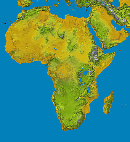
Topography of Africa
image description here:
- PIA04965: SRTM Data Release for Africa, Colored Height
- Elevation data at the highest possible resolution from NASA's SRTM mission in February 2000 are being released for the first time for most of the African continent. This color shaded relief image shows the extent of SRTM digital elevation data for Africa.
- This color shaded relief image shows the extent of digital elevation data for Africa recently released by the Shuttle Radar Topography Mission (SRTM). This release includes data for all of the continent, plus the island of Madagascar and the Arabian Peninsula. SRTM flew on board the Space Shuttle Endeavour in February 2000 and used an interferometric radar system to map the topography of Earth's landmass between latitudes 56 degrees south and 60 degrees north.
larger version here Image credit: NASA/JPL-Caltech
| 本文件完全由NASA创作,在美国属于公有领域。根据NASA的版权方针,NASA的材料除非另有声明否则不受版权保护。(参见Template:PD-USGov/zh、NASA版权方针页面或JPL图片使用方针。) | ||
 |
警告:
|
文件历史
点击某个日期/时间查看对应时刻的文件。
| 日期/时间 | 缩略图 | 大小 | 用户 | 备注 | |
|---|---|---|---|---|---|
| 当前 | 2006年1月27日 (五) 13:01 | | 1,463 × 1,600(475 KB) | Perconte~commonswiki | |
| 2005年9月25日 (日) 10:34 |  | 552 × 604(48 KB) | ChongDae | This image was copied from wikipedia:en. The original description was: Topography of Africa image description [http://photojournal.jpl.nasa.gov/catalog/PIA04965 here] larger version [http://photojournal.jpl.nasa.gov/jpeg/PIA04965.jpg here] Image credi |
文件用途
没有页面使用本文件。
全域文件用途
以下其他wiki使用此文件:
- ar.wikipedia.org上的用途
- cs.wikipedia.org上的用途
- cy.wikipedia.org上的用途
- de.wikipedia.org上的用途
- eml.wikipedia.org上的用途
- eo.wikipedia.org上的用途
- es.wikipedia.org上的用途
- et.wikipedia.org上的用途
- eu.wikipedia.org上的用途
- fa.wikipedia.org上的用途
- hy.wikipedia.org上的用途
- ie.wikipedia.org上的用途
- incubator.wikimedia.org上的用途
- it.wikipedia.org上的用途
- it.wikibooks.org上的用途
- it.wikiversity.org上的用途
- ja.wikipedia.org上的用途
- kab.wikipedia.org上的用途
- ka.wikipedia.org上的用途
- kn.wikipedia.org上的用途
- ko.wikipedia.org上的用途
- lld.wikipedia.org上的用途
- lmo.wikipedia.org上的用途
- ml.wikipedia.org上的用途
- nl.wikipedia.org上的用途
- nrm.wikipedia.org上的用途
- pl.wikipedia.org上的用途
- pms.wikipedia.org上的用途
查看本文件的更多全域用途。