File:Typhoon Chataan 08 july 2002 0400Z.jpg

本预览的尺寸:458 × 599像素。 其他分辨率:183 × 240像素 | 367 × 480像素 | 587 × 768像素 | 783 × 1,024像素 | 1,566 × 2,048像素 | 5,200 × 6,800像素。
原始文件 (5,200 × 6,800像素,文件大小:3.75 MB,MIME类型:image/jpeg)
摘要
| 描述 |
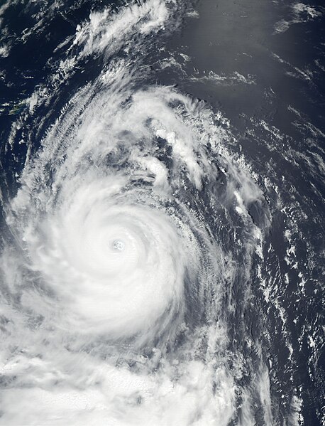
Super Typhoon Chataan reached Category 4 hurricane status on July 7 and 8, about the time this image from the Moderate Resolution Imaging Spectroradiometer (MODIS) was captured on July 8, 2002. Chataan was located in the Pacific Ocean off the south of Japan, and the outlines of Ryukyu Islands, southwest of Japan, are visible at the top left of the image. The southernmost of those islands is Okinawa. According to news reports, tens of thousands of people were asked to evacuate low-lying coastal areas as the storm skirted the east coast of the Japan, bringing high winds and heavy rains that produced floods and mudslides in the region, and disrupted transportation services. Typhoon Chataan was reportedly responsible for the deaths of at least 80 people in Micronesia, the Philippines, and Japan. Even as Chataan passed up the coast of Japan and moved northeast, another storm began brewing to the south. Now the country is bracing for the expected arrival of Typhoon Halong from the southeast and Tropical Storm Nakri from the south. |
|||||
| 日期 | ||||||
| 来源 | http://visibleearth.nasa.gov/view_rec.php?id=3675 | |||||
| 作者 | Jacques Descloitres, MODIS Land Rapid Response Team, NASA/GSFC | |||||
| 授权 (二次使用本文件) |
|

文件历史
点击某个日期/时间查看对应时刻的文件。
| 日期/时间 | 缩略图 | 大小 | 用户 | 备注 | |
|---|---|---|---|---|---|
| 当前 | 2006年12月2日 (六) 16:32 | | 5,200 × 6,800(3.75 MB) | Good kitty | == Summary == {{Information |Description=Super Typhoon Chataan reached Category 4 hurricane status on July 7 and 8, wabout the time this image from the Moderate Resolution Imaging Spectroradiometer (MODIS) was captured on July 8, 2002. Chataan was located |
文件用途
以下15个页面使用本文件:
- 2002年太平洋颱風季
- 颱風查特安
- Talk:颱風查特安
- User:MCC214/2002年太平洋颱風季
- Wikipedia:优良条目/2016年4月
- Wikipedia:优良条目/2016年4月9日
- Wikipedia:优良条目/台风查特安
- Wikipedia:典范条目/2016年5月
- Wikipedia:典范条目/2016年5月29日
- Wikipedia:典范条目/2018年9月
- Wikipedia:典范条目/2018年9月2日
- Wikipedia:典范条目/2022年5月
- Wikipedia:典范条目/2022年5月14日
- Wikipedia:典范条目/颱風查特安
- WikiProject:太平洋颱風季/條目/典範條目
全域文件用途
以下其他wiki使用此文件:
- en.wikipedia.org上的用途
- es.wikipedia.org上的用途
- ko.wikipedia.org上的用途
- pl.wikipedia.org上的用途
- vi.wikipedia.org上的用途