File:Uruguay T2.png

本预览的尺寸:527 × 599像素。 其他分辨率:211 × 240像素 | 422 × 480像素 | 691 × 786像素。
原始文件 (691 × 786像素,文件大小:1.18 MB,MIME类型:image/png)
摘要
| 描述 |
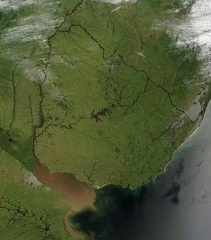
Español: Foto de Uruguay tomada desde satélite. Se aprecian claramente los límites con Brasil y Argentina, y el Río de la Plata al sur.
English: Photo of Uruguay taken from satellite, where the limits with Brazil and Argentina are clearly appreciated, as well as the Río de la Plata to the south. |
| 日期 | |
| 来源 | http://visibleearth.nasa.gov/view_rec.php?id=4817 |
| 作者 | Jeff Schmaltz, MODIS Rapid Response Team, NASA/GSFC |
许可协议
| 本文件完全由NASA创作,在美国属于公有领域。根据NASA的版权方针,NASA的材料除非另有声明否则不受版权保护。(参见Template:PD-USGov/zh、NASA版权方针页面或JPL图片使用方针。) | ||
 |
警告:
|
文件历史
点击某个日期/时间查看对应时刻的文件。
| 日期/时间 | 缩略图 | 大小 | 用户 | 备注 | |
|---|---|---|---|---|---|
| 当前 | 2004年11月29日 (一) 04:11 | | 691 × 786(1.18 MB) | Tano4595 | Uruguay_satelite |
文件用途
以下页面使用本文件:
全域文件用途
以下其他wiki使用此文件:
- af.wikipedia.org上的用途
- als.wikipedia.org上的用途
- an.wikipedia.org上的用途
- ar.wikipedia.org上的用途
- ast.wikipedia.org上的用途
- azb.wikipedia.org上的用途
- ba.wikipedia.org上的用途
- bg.wikipedia.org上的用途
- ca.wikipedia.org上的用途
- cs.wikipedia.org上的用途
- da.wikipedia.org上的用途
- de.wikipedia.org上的用途
- el.wikipedia.org上的用途
- en.wikipedia.org上的用途
- en.wikibooks.org上的用途
- eo.wikipedia.org上的用途
- es.wikipedia.org上的用途
- eu.wikipedia.org上的用途
- fr.wikipedia.org上的用途
- gcr.wikipedia.org上的用途
- hi.wikipedia.org上的用途
- hr.wikipedia.org上的用途
- hu.wikipedia.org上的用途
- hy.wikipedia.org上的用途
- hyw.wikipedia.org上的用途
- is.wikipedia.org上的用途
- it.wikipedia.org上的用途
- ku.wikipedia.org上的用途
- la.wikipedia.org上的用途
- li.wikipedia.org上的用途
- lv.wikipedia.org上的用途
- ms.wikipedia.org上的用途
- mt.wikipedia.org上的用途
- oc.wikipedia.org上的用途
- os.wikipedia.org上的用途
- pcd.wikipedia.org上的用途
- pl.wikipedia.org上的用途
查看本文件的更多全域用途。