File:Whitehall1680.jpg
本预览的尺寸:800 × 571像素。 其他分辨率:320 × 229像素 | 640 × 457像素 | 1,024 × 732像素 | 1,280 × 914像素 | 1,691 × 1,208像素。
原始文件 (1,691 × 1,208像素,文件大小:428 KB,MIME类型:image/jpeg)
摘要
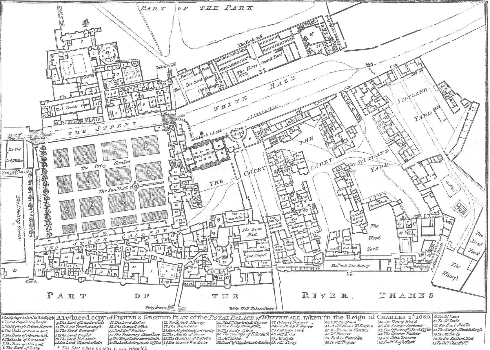
English: Fisher's ground plan of the Palace of Whitehall in London in 1680. This 1807 edition is from the Crace Collection at the British Library. The annotations may more easily be read on the zoomable version here. The black spot outside the Banqueting House marks the spot where Charles I was executed.
Français : Plan du palais de Whitehall en 1680 (le nord est à droite), la Maison des banquets est au centre du plan.
Español: Plano del Palacio de Whitehall en 1680 (el norte está a la derecha de la imagen); la 'Casa de los Banquetes' está al centro del plano.
许可协议
|
本作品在其来源国以及其他著作权期限是作者逝世后70年或以下的国家和地区属于公有领域。 | |
| 本文件已被确认为免除已知的著作权法限制(包括所有相关权利)。 | |
文件历史
点击某个日期/时间查看对应时刻的文件。
| 日期/时间 | 缩略图 | 大小 | 用户 | 备注 | |
|---|---|---|---|---|---|
| 当前 | 2011年3月20日 (日) 17:52 | | 1,691 × 1,208(428 KB) | Alexrk2 | larger size |
| 2006年2月23日 (四) 18:03 |  | 712 × 512(171 KB) | Merchbow~commonswiki | Fisher's ground plan of the Palace of Whitehall in London in 1680. This 1807 edition is from the Crace Collection at the British Library. Category:Palace of Whitehall Category:Architectural plans |
文件用途
以下页面使用本文件:
全域文件用途
以下其他wiki使用此文件:
- en.wikipedia.org上的用途
- en.wikinews.org上的用途
- es.wikipedia.org上的用途
- fa.wikipedia.org上的用途
- fr.wikipedia.org上的用途
- hy.wikipedia.org上的用途
- it.wikipedia.org上的用途
- ru.wikipedia.org上的用途
- sl.wikipedia.org上的用途
- tr.wikipedia.org上的用途
- uk.wikipedia.org上的用途
- uz.wikipedia.org上的用途