聖塔菲撞擊結構
35°45′N 105°56′W / 35.750°N 105.933°W
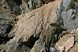
 475號新墨西哥州公路旁,聖塔菲撞擊結構的破裂錐 | |
| 撞击坑/结构 | |
|---|---|
| 信心 | 已确认[1] |
| 直径 | 6公里(3.7英里)-13公里(8.1英里) |
| 年龄 | 不到12亿年 |
| 暴露 | 否 |
| 已钻探 | 否 |
| 位置 | |
| 位置 | 桑格雷克里斯托山脉 |
| 地理坐标系 | 35°45′N 105°56′W / 35.750°N 105.933°W |
| 国家 | 美国 |
| 州 | 新墨西哥州 |
| 地区 | 圣菲县 |
| 路线 | 圣菲东北部的SR475 |
聖塔菲撞擊結構(英語:Santa Fe impact structure)是位於美國新墨西哥州聖塔菲東北部[1]的受侵蝕的撞擊坑殘餘,直徑約6到13公里。該撞擊坑是在2005年時由一位地質學家注意到位於聖塔菲和海德纪念州立公园之間475號新墨西哥州公路切過區域岩石中的破裂錐而發現。破裂錐是岩石受到撞擊事件或核爆的震波而形成的結構[2]。
該區域因為受到嚴重侵蝕,被稱為「撞擊結構」,而非撞擊坑。對當地最近一次定年的結果顯示它在大約14到16億年前形成。現在只留下撞擊坑的基岩在山脈中的露頭。近年的研究開始推測它的直徑。它的破裂錐沿著公路總共散布了約1.6公里,因此其直徑必定遠大於這個範圍[3][4]。
參見
编辑參考資料
编辑- ^ 1.0 1.1 Santa Fe. Earth Impact Database. University of New Brunswick. [2010-03-16].
- ^ French, Bevan M. Traces of catastrophe. Lunar and Planetary Institute. 1998 [2008-12-31]. (原始内容存档于2017-07-15).
- ^ Fackelman, S.P.; T. H. McElvain, J. R. Morrow, and C. Koeberl. Shatter Cone Exposures Indicate a New Bolide Impact Structure near Santa Fe, New Mexico (PDF). Lunar and Planetary Science XXXVIII. Lunar and Planetary Institute. 2007 [2008-12-31]. (原始内容存档 (PDF)于2016-03-03).
- ^ Tegtmeier, E. L.; H. E. Newsom, W. E. Elston, and T. H. McElvain. Breccias and geological setting of the Santa Fe, New Mexico USA impact structure (PDF). Large Meteorite Impacts and Planetary Evolution IV. Lunar and Planetary Institute. 2008 [2008-12-31]. (原始内容存档 (PDF)于2016-03-03).
