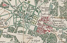
卡西尼地图
卡西尼地图(法语:Carte de Cassini),又称学院地图(carte de l'Académie),是全法兰西王国第一幅地形图与几何地图。[1]该地图由卡西尼家族所绘,主要由塞萨尔-弗朗索瓦·卡西尼(卡西尼三世)与他的儿子让-多米尼克·卡西尼(卡西尼四世)于18世纪所绘。

地图上1刻度表示100土瓦兹,而1土瓦兹长864个刻度,即地图比例为1/86400。[2]
在当时,该地图是真正的创新与决定性的技术进展。它是第一幅以大地三角测量为基础的地图,[3]卡西尼家族四代人相继工作,历经六十多年才得以绘成。[4]该地图并不能精确地定位房屋或是沼泽地与森林的边界,但若将卫星照片叠加到地图上,就能展现出地图道路网惊人的精度。
卡西尼家族的工作甚至在野外留下了自己的印记,即使在今天,我们仍然可以找到被称为“卡西尼标记”(Signal de Cassini)的地名,这些地名揭示了当时测量的地方。[5]这些参考点对应着无数个三角形的顶点,构成了卡西尼地图的网格。
如今,研究人员经常查阅卡西尼号地图,有的在法国国家图书馆地图部(Département des cartes et plans de la Bibliothèque nationale de France)的阅览室查阅纸质版,有的在网上查阅电子版。[6]
地图
编辑参考文献
编辑- ^ Porebski, Annie. Histoire du collège Marmontel à Bort-les-Orgues. BoD - Books on Demand. 2019-05-05: 46 [2020-04-27]. ISBN 978-2-322-09282-6. (原始内容存档于2020-05-05) (法语).
- ^ Annales forestières: faisant suite au Mémorial forestier, ou, Recueil complet des lois, arrêts. et instructions relatifs à l'Administration forestière, etc. Chez A.-Bertrand. 1808: 227 [2020-04-27]. (原始内容存档于2020-05-05) (法语).
- ^ Bernardi, Gabriella. Giovanni Domenico Cassini: A Modern Astronomer in the 17th Century. Springer. 2017-10-14: 103 [2020-04-27]. ISBN 978-3-319-63468-5. (原始内容存档于2020-05-05) (英语).
- ^ Hewitt, Rachel. The French Connection. Map Of A Nation: A Biography of the Ordnance Survey. Granta Books. 2011-07-07: 64 [2020-04-27]. ISBN 978-1-84708-452-1. (原始内容存档于2020-05-05) (英语).
- ^ Bernardi, Gabriella. Curiosity. Giovanni Domenico Cassini: A Modern Astronomer in the 17th Century. Springer. 2017-10-14: 108 [2020-04-27]. ISBN 978-3-319-63468-5. (原始内容存档于2020-05-05) (英语).
- ^ Des villages Cassini aux communes d'aujourd'hui. cassini.ehess.fr. [2019-08-11]. (原始内容存档于2016-11-25).