国家首都区
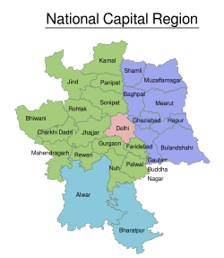
国家首都区(National Capital Region,常缩写为NCR)是指范围涵盖德里国家首都辖区及周围加济阿巴德、古尔冈、索尼帕特、诺伊达、法里达巴德、巴哈杜尔加尔等地区的德里大都会区。
| 国家首都区 राष्ट्रीय राजधानी क्षेत्र | |
|---|---|
 Landsat-5卫星所拍摄的德里大都会区 | |
 国家首都区的范围 | |
| 坐标:28°42′N 77°12′E / 28.7°N 77.2°E | |
| 国家 | |
| 邦 | 德里国家首都辖区 哈里亚纳邦 拉贾斯坦邦 北方邦 |
| 主要城市 | 德里, 加济阿巴德, 索尼帕特, 法里达巴德, 古尔冈, 诺伊达 |
| 政府 | |
| • 区域主管机构 | 国家首都区计划局 |
| 面积[1][2] | |
| • 总计 | 54,984 平方公里(21,229 平方英里) |
| 人口(2011)[2]:6 | |
| • 总计 | 46,069,000人 |
| • 密度 | 838人/平方公里(2,170人/平方英里) |
| 网站 | ncrpb |
参考文献
编辑- ^ NCR Constituent Areas. National Capital Region Planning Board. Ministry of Urban Development, Government of India. [1 June 2015]. (原始内容存档于2018年12月26日).
- ^ 2.0 2.1 Census 2011 (PDF). National Capital Region Planning Board. National Informatics Centre: 3. [26 March 2016]. (原始内容 (PDF)存档于2016-04-06).
| 这是一篇有关印度地理的小作品。您可以通过编辑或修订扩充其内容。 |