| 了解更多 此条目需要扩充。 (2018年3月25日) |
塔拉瓦(英语:Tarawa),是基里巴斯的一组环礁和首都,英国殖民时期吉尔伯特和埃利斯群岛的首府。塔拉瓦环礁是以第二次世界大战的塔拉瓦战役而闻名。


地理
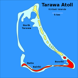
编辑塔拉瓦环礁由24个岛屿组成,其中8个有人居住,最大的岛屿南塔拉瓦,由邦里基沿整个南侧延伸至拜里基,除了贝蒂奥的潟湖。日本堤道连接拜里基至贝蒂奥。最大城市是帕埃尼尤和唯一的机场-邦里基国际机场,均在南塔拉瓦。
小岛
编辑- 阿巴尼亚(Abanuea)(已于1999年淹没)
- 阿巴奥科罗(Abaokoro)
- 阿巴塔奥(Abatao)
- 拜里基(Bairiki)
- 贝寿(Beito)
- 拜克曼岛(Bikeman Island)(已于1999年淹没)
- 比克塔瓦(Biketawa)
- 邦里基(Bonriki)
- 布阿里基(Buariki)
城镇
编辑气候
编辑| 邦里基国际机场 (南塔拉瓦) | |||||||||||||
|---|---|---|---|---|---|---|---|---|---|---|---|---|---|
| 月份 | 1月 | 2月 | 3月 | 4月 | 5月 | 6月 | 7月 | 8月 | 9月 | 10月 | 11月 | 12月 | 全年 |
| 历史最高温 °C(°F) | 35.0 (95.0) |
33.0 (91.4) |
35.0 (95.0) |
34.5 (94.1) |
34.5 (94.1) |
33.5 (92.3) |
34.5 (94.1) |
34.5 (94.1) |
34.5 (94.1) |
35.0 (95.0) |
35.0 (95.0) |
35.0 (95.0) |
35.0 (95.0) |
| 平均高温 °C(°F) | 30.7 (87.3) |
30.6 (87.1) |
30.7 (87.3) |
30.7 (87.3) |
30.8 (87.4) |
30.8 (87.4) |
30.9 (87.6) |
31.0 (87.8) |
31.1 (88.0) |
31.2 (88.2) |
31.3 (88.3) |
30.9 (87.6) |
30.9 (87.6) |
| 日均气温 °C(°F) | 28.2 (82.8) |
28.1 (82.6) |
28.1 (82.6) |
28.2 (82.8) |
28.4 (83.1) |
28.3 (82.9) |
28.2 (82.8) |
28.3 (82.9) |
28.4 (83.1) |
28.6 (83.5) |
28.5 (83.3) |
28.2 (82.8) |
28.3 (82.9) |
| 平均低温 °C(°F) | 25.3 (77.5) |
25.3 (77.5) |
25.2 (77.4) |
25.3 (77.5) |
25.5 (77.9) |
25.3 (77.5) |
25.1 (77.2) |
25.2 (77.4) |
25.3 (77.5) |
25.4 (77.7) |
25.4 (77.7) |
25.3 (77.5) |
25.3 (77.5) |
| 历史最低温 °C(°F) | 21.5 (70.7) |
22.5 (72.5) |
22.5 (72.5) |
22.5 (72.5) |
21.0 (69.8) |
21.0 (69.8) |
21.0 (69.8) |
21.5 (70.7) |
22.5 (72.5) |
22.0 (71.6) |
22.5 (72.5) |
22.0 (71.6) |
21.0 (69.8) |
| 平均降水量 mm(英寸) | 271 (10.7) |
218 (8.6) |
204 (8.0) |
184 (7.2) |
158 (6.2) |
155 (6.1) |
168 (6.6) |
138 (5.4) |
120 (4.7) |
110 (4.3) |
115 (4.5) |
212 (8.3) |
2,052 (80.8) |
| 平均降水天数(≥ 0.3 mm) | 15 | 12 | 14 | 15 | 15 | 14 | 16 | 18 | 15 | 11 | 10 | 17 | 172 |
| 平均相对湿度(%) | 81 | 80 | 81 | 82 | 81 | 81 | 80 | 79 | 77 | 77 | 79 | 81 | 80 |
| 月均日照时数 | 220.1 | 192.1 | 207.7 | 201.0 | 229.4 | 219.0 | 229.4 | 257.3 | 243.0 | 260.4 | 240.0 | 189.1 | 2,688.5 |
| 日均日照时数 | 7.1 | 6.8 | 6.7 | 6.7 | 7.4 | 7.3 | 7.4 | 8.3 | 8.1 | 8.4 | 8.0 | 6.1 | 7.4 |
| 数据来源:Deutscher Wetterdienst[1] | |||||||||||||
人口
编辑1990年的人口为28,802人,大部分为吉尔伯特人(密克罗尼西亚人),这可能超过本身环境承载力,但在澳洲、日本和新西兰的援助下,使岛屿没有出现饥荒。
在1995年至2000年间,出现一股移民潮涌入南塔拉瓦,使城市化率增加至5.2%[2]。虽然移民潮在接下五年变定稳定,但在某些地区仍出现人口过多问题。人口过多问题引起政府对南塔拉瓦的不可持续发展的关注[3],汤安诺实行了不同措施,以纾缓该国的主要城市中心的问题,包括在岛屿不同的地方兴建发展,以纾缓环礁中心的挤迫问题[4]。
行政区划
编辑塔拉瓦环礁可分为三个行政区:
- 泰奈纳诺市政局:南塔拉瓦
- 贝寿镇议会:贝寿岛
- 北塔拉瓦:邦里基以东的所有岛屿
基里巴斯的主要行政区是南塔拉瓦的邦里基,国会位于昂波岛,部分行政机构在贝寿岛、帕埃尼尤和圣诞岛。
历史
编辑东印度公司的夏洛特号船长托马斯·吉尔伯特在1788年6月20日到达塔拉瓦[5],是首位描述塔拉瓦的欧洲人,他的草图保存至今天。
亚瑟·格林布尔爵士在1913年至1919年间为塔拉瓦的见习行政人员[6],并在1926年成为吉尔伯特及埃里斯群岛属地代表[7] 。
二战期间,塔拉瓦环礁被日本占领。1943年11月20日,美国发动残酷的塔拉瓦战役,日军利用地形优势使美国海军陆战队蒙受巨大的伤亡,3日后攻占该岛,双方共约6,000人阵亡。
经济
编辑贝蒂欧岛是椰子核和珍珠的主要出口港。南太平洋船务公司是位于塔拉瓦的船员机构,约950名海员在世界各地替南太平洋船务公司工作。
基里巴斯的货币是澳元。
纪念
编辑参考资料
编辑- ^ Klimatafel von Tarawa, Int. Flugh. Bonriki / Kiribati (Gilbert-Inseln) (PDF). Baseline climate means (1961–1990) from stations all over the world. Deutscher Wetterdienst. [30 November 2020]. (原始内容存档 (PDF)于2022-10-13) (德语).
- ^ Kiribati health information profile. World Health Organization - Western Pacific Ocean. World Health Organization. [9 June 2011]. (原始内容存档于2011年6月8日).
- ^ Kiribati profile on New Zealand's Ministry of Foreign Affairs and Trade official Site. New Zealand's Ministry of Foreign Affairs and Trade. [9 June 2011]. (原始内容存档于2013-04-11).
- ^ Pareti, Samisoni. Politics: Easing congestion and overcrowding. Island Business (Islands Business International). [9 June 2011]. (原始内容存档于2012年3月23日).
- ^ Samuel Eliot Morison. The Gilberts & Marshalls: A distinguished historian recalls the past of two recently captured pacific groups. Life magazine. 1944-05-22 [2009-10-14]. (原始内容存档于2020-08-07).
Being now abreast of this island, the extremity ending in a beautiful clump of trees, I hauled up to look at the bay. It appeared to be safe and commodious, sheltered by a long reef running parallel with the island, with two large inlets into the bay. The reef is about 3/4 of a mile from the beach, and has several small islands which appear like flower pots.
- ^ Grimble, Sir Arthur. A Pattern of Islands. Early New Zealand Books (NZETC). 1952 [16 Oct 2011]. (原始内容存档于2012-05-21).
- ^ Grimble, Sir Arthur. A Pattern of Islands. John Murray & Co, London, 1952; republished 2011 by Eland, London. ISBN 978-1906011-45-1.
外部链接
编辑- Tarawa on The Web - A History of the Bloodiest Battle (页面存档备份,存于互联网档案馆)
- The Marine Assault of Tarawa (页面存档备份,存于互联网档案馆)
- Tarawa the Aftermath (页面存档备份,存于互联网档案馆)
- "Tarawa" the USCG cat Archive.is的存档,存档日期2014-05-23
- Exhibit: The Alfred Agate Collection: The United States Exploring Expedition, 1838-1842 from the Navy Art Gallery