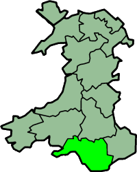
格拉摩根
威尔士历史郡
(重定向自格拉摩根郡)
格拉摩根(英语:Glamorgan,威尔士语:Morgannwg [mɔrˈɡanʊɡ]),又称格拉摩根郡,是威尔士的13个历史上的郡之一,也是威尔士第一级行政区划。格拉摩根地区最初是以农牧业为主的地区。不过16世纪之后,由于这里的自然资源,格拉摩根成为工业革命中威尔士最早工业化的地区,也成为威尔士人口最密集的地区。格拉摩根地区面积2,100 km2(811 sq mi),1991年有人口1,288,309.[5]。卡迪夫和斯旺西是格拉摩根地区的两大城市。
| 格兰摩根名誉郡 英语:Glamorgan 威尔士语:Morgannwg | |
|---|---|
 2013年采用的格拉摩根郡旗 | |
 Ancient extent of Glamorgan | |
| 坐标:51°40′00″N 3°40′00″W / 51.666666666667°N 3.6666666666667°W | |
| 首府 | 卡迪夫 |
| 面积 | |
| • 1861 | 547,494英亩(2,215.63平方千米)[1] |
| • 1911 | 518,865英亩(2,099.77平方千米)[2] |
| • 1961 | 523,253英亩(2,117.53平方千米)[2] |
| 人口 | |
| • 1861 | 326,254[1] |
| • 1911 | 1,120,910[2] |
| • 1961 | 1,229,728[2] |
| 密度 | |
| • 1861 | 1.7/acre |
| • 1911 | 2.2/acre |
| • 1961 | 2.4/acre |
| 政府 | 格兰摩根郡议会(1889–1974) |
| • 座右铭 | A Ddioddefws A Orfu (受苦者必将战胜)[3][4] |
参考资料
编辑- ^ 1.0 1.1 School's Enquiry Commission, Vol VIII (1935) Eyre & Spottiswoode, London. Archive.org. [19 February 2012].
- ^ 2.0 2.1 2.2 2.3 Vision of Britain - Glamorgan population (页面存档备份,存于互联网档案馆) (area (页面存档备份,存于互联网档案馆))
- ^ Geoffrey Briggs, Civic and Corporate Heraldry, London, 1971
- ^ C Wilfrid Scott-Giles, Civic Heraldry of England and Wales, 2nd edition, London, 1953
- ^ Office for National Statistics: 1991 Census County Monitor (Wales). statistics.gov.uk. 1991 [19 February 2012]. (原始内容存档于2009-03-13).
- Conduit, Brian. Brecon Beacons and Glamorgan Walks. Pathfinder Guide. Norwich: Jarrold Publishing and Ordnance Survey. 1997. ISBN 0-7117-0671-9.
- Davies, John; Jenkins, Nigel. The Welsh Academy Encyclopaedia of Wales. Cardiff: University of Wales Press. 2008. ISBN 978-0-7083-1953-6.
- Evans, C. J. O. Glamorgan, its History and Topography. Cardiff: William Lewis. 1948.
- Evans, D. Gareth. A history of Wales 1815–1906. Cardiff: University of Wales Press. 1989. ISBN 978-0708323847.
- Jenkins, Philip. A History of Modern Wales 1536–1990. Harlow: Longman. 1992. ISBN 0-582-48925-3.
- Lewis, E. D. The Rhondda Valleys. London: Phoenix House. 1959.
- Newman, John. Glamorgan. London: Penguin Group. 1995. ISBN 0-14-071056-6.
- Morgan, Kenneth O. Democratic Politics in Glamorgan, 1884-1914. Morgannwg. 1960, 4: 5–27 [2016-02-29]. (原始内容存档于2023-08-06).
- Morgan, Kenneth. Rebirth of a Nation: Wales 1880–1980. Oxford: Oxford University Press. 1982. ISBN 0-19-821760-9.
- Thomas, Norman Lewis. The Story of Swansea's Districts and Villages. Neath: The Guardian Press (Neath) Ltd. 1966.
- Wade, J. H. Glamorganshire. London: Cambridge University Press. 1914.