File:12E Hurricane Kristy 2006.jpg

本预览的尺寸:571 × 600像素。 其他分辨率:228 × 240像素 | 457 × 480像素 | 731 × 768像素 | 975 × 1,024像素 | 1,949 × 2,048像素 | 4,419 × 4,643像素。
原始文件 (4,419 × 4,643像素,文件大小:12.47 MB,MIME类型:image/jpeg)
摘要
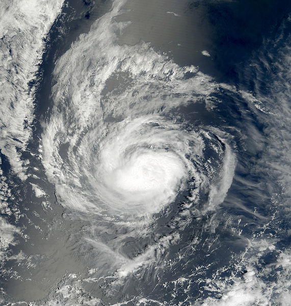
| 描述 | This image of Hurricane Kristy was captured by the MODIS instrument on NASA's Terra satellite at 1843 UTC on August 31, 2006 when it was located in the eastern Pacific Ocean. At the time, maximum sustained winds were 75 mph and the minimum pressure was approximately 987 mb. | ||||||
| 日期 | |||||||
| 来源 | http://www.nrlmry.navy.mil/tc_pages/tc_home.html | ||||||
| 作者 | Naval Research Laboratory | ||||||
| 授权 (二次使用本文件) |
|
||||||

文件历史
点击某个日期/时间查看对应时刻的文件。
| 日期/时间 | 缩略图 | 大小 | 用户 | 备注 | |
|---|---|---|---|---|---|
| 当前 | 2013年3月5日 (二) 21:17 | | 4,419 × 4,643(12.47 MB) | Supportstorm | Color |
| 2006年9月5日 (二) 19:45 |  | 3,220 × 3,220(1.58 MB) | Good kitty | == Summary == {{Information |Description=This image of Hurricane Kristy was captured at 1843 UTC on August 31, 2006 when it was located in the eastern Pacific Ocean. At the time, maximum sustained winds were 75 mph and the minimum pressure was approximate |
文件用途
以下6个页面使用本文件:
全域文件用途
以下其他wiki使用此文件:
- de.wikipedia.org上的用途
- en.wikipedia.org上的用途
- es.wikipedia.org上的用途
- pt.wikipedia.org上的用途
- simple.wikipedia.org上的用途