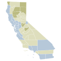
File:2020 California Proposition 19 results map by county.svg

原始文件 (SVG文件,尺寸为744 × 744像素,文件大小:595 KB)


摘要

描述
English: Each shade represents a 10% difference.

Support

 
90%–100%
 
80%–90%
 
70%–80%
 
60%–70%
 
50%–60%

Tie

 
Exact tie

Oppose

 
50%–60%
 
60%–70%
 
70%–80%
 
80%–90%
 
90%–100%
日期
来源 自己的作品
作者 Fluffy89502
image extraction process This file has been created using a standardized map of a state's counties: California county map, cb 500k.svg.
A full list of available maps exists at Category:Standardized SVG county maps of US states.
original file

许可协议

Public domain 此地图不符合版权的资格,因此属于公有领域,因为其完全包含公共财产信息,不包含原作者身份。详情参见Commons:Threshold of originality § Maps

English | Español | Galego | Română | slovenščina | العربية | 简体中文 | 繁體中文 | +/−

说明

添加一行文字以描述该文件所表现的内容

此文件中描述的项目

描绘内容

文件来源 简体中文(已转写)

上传者的原创作品 简体中文(已转写)

image/svg+xml

校验和 简体中文(已转写)

9fb9c9bb3307aca22de70173be0c053729c6e559

断定方法:​SHA-1 简体中文(已转写)

数据大小 简体中文(已转写)

609,344 字节

744 像素

744 像素

文件历史

点击某个日期/时间查看对应时刻的文件。

日期/时间缩⁠略⁠图大小用户备注
当前2022年11月7日 (一) 05:072022年11月7日 (一) 05:07版本的缩略图744 × 744(595 KB)Ellistandard colors and shapes
2020年12月9日 (三) 05:332020年12月9日 (三) 05:33版本的缩略图167 × 284(84 KB)Fluffy89502Uploaded own work with UploadWizard

以下页面使用本文件:

全域文件用途

以下其他wiki使用此文件:

元数据