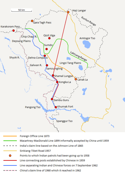
File:Aksai Chin Sino-Indian border map.png

本预览的尺寸:429 × 600像素。 其他分辨率:172 × 240像素 | 624 × 872像素。
原始文件 (624 × 872像素,文件大小:102 KB,MIME类型:image/png)
文件历史
点击某个日期/时间查看对应时刻的文件。
| 日期/时间 | 缩略图 | 大小 | 用户 | 备注 | |
|---|---|---|---|---|---|
| 当前 | 2020年9月7日 (一) 20:06 |  | 624 × 872(102 KB) | The Discoverer | Removed Tibet-Sinkiang boundary, added label for Amtogor Tso. |
| 2020年6月9日 (二) 02:51 |  | 624 × 872(102 KB) | MarkH21 | Intended change from the last edit (i.e. latest version with "informally" per references in talk discussion) | |
| 2020年6月9日 (二) 02:29 |  | 624 × 872(101 KB) | MarkH21 | Reverted to version as of 00:21, 7 February 2018 (UTC) This was the previous version; the addition of “accepted by China until 1959” was the contested change, not the revert to the original description (the refs are also now dead, but previously said tacit acceptance which isn’t outright acceptance) | |
| 2018年4月23日 (一) 19:37 |  | 624 × 872(102 KB) | The Discoverer | Reverted to version as of 09:10, 13 December 2017 (UTC) The file of 12 December removes a statement that is supported by the source. As per COM:OVERWRITE, "Controversial or contested changes should be uploaded to a separate filename" | |
| 2018年2月7日 (三) 00:21 |  | 624 × 872(101 KB) | 樂號 | Reverted to version as of 23:05, 12 December 2017 (UTC) | |
| 2017年12月13日 (三) 09:10 |  | 624 × 872(102 KB) | The Discoverer | Reverted to version as of 11:07, 19 February 2017 (UTC) The file of 12 December removes a statement that is supported by the source. As per COM:OVERWRITE, "Controversial or contested changes should be uploaded to a separate filename" | |
| 2017年12月12日 (二) 23:05 |  | 624 × 872(101 KB) | 樂號 | Macartney–MacDonald Line is only proposed by Britain No official accept made by China | |
| 2017年2月19日 (日) 11:07 |  | 624 × 872(102 KB) | The Discoverer | Added Karakoram Pass and Kunlun Range | |
| 2015年4月1日 (三) 15:26 |  | 624 × 872(59 KB) | RokerHRO | optipng -o7 -i0 → 40.77% decrease | |
| 2014年10月2日 (四) 15:00 |  | 624 × 872(99 KB) | The Discoverer | Uploaded correct file with scale added. |
文件用途
全域文件用途
以下其他wiki使用此文件:
- ast.wikipedia.org上的用途
- as.wikipedia.org上的用途
- az.wikipedia.org上的用途
- bh.wikipedia.org上的用途
- bn.wikipedia.org上的用途
- ca.wikipedia.org上的用途
- de.wikipedia.org上的用途
- en.wikipedia.org上的用途
- es.wikipedia.org上的用途
- fr.wikipedia.org上的用途
- hi.wikipedia.org上的用途
- id.wikipedia.org上的用途
- it.wikipedia.org上的用途
- ja.wikipedia.org上的用途
- ka.wikipedia.org上的用途
- kn.wikipedia.org上的用途
- ko.wikipedia.org上的用途
- lv.wikipedia.org上的用途
- ml.wikipedia.org上的用途
- ms.wikipedia.org上的用途
- nl.wikipedia.org上的用途
- no.wikipedia.org上的用途
- or.wikipedia.org上的用途
- pl.wikipedia.org上的用途
- pt.wikipedia.org上的用途
- ro.wikipedia.org上的用途
- ru.wikipedia.org上的用途
- ru.wikinews.org上的用途
- sr.wikipedia.org上的用途
- ta.wikipedia.org上的用途
- te.wikipedia.org上的用途
- uk.wikipedia.org上的用途
- vi.wikipedia.org上的用途
查看此文件的更多全域用途。


