File:Antarctic Peninsula, the Larsen Ice Shelf, and the sea ice covered waters around the region.jpg

本预览的尺寸:468 × 599像素。 其他分辨率:187 × 240像素 | 375 × 480像素 | 600 × 768像素 | 800 × 1,024像素 | 1,600 × 2,048像素 | 5,000 × 6,400像素。
原始文件 (5,000 × 6,400像素,文件大小:4.51 MB,MIME类型:image/jpeg)
摘要
| 描述 |
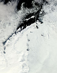
English: Clear view of the Antarctic Peninsula, the Larsen Ice Shelf, and the sea ice covered waters around the region. The Peninsula stands out as the raised terrain amidst the ice from the lower left to upper middle of the image. |
| 日期 | |
| 来源 | NASA Earth Observatory |
| 作者 | Jeff Schmaltz |
Image captured by the Moderate Resolution Imaging Spectroradiometer (MODIS) on NASA’s Aqua satellite. NASA image provided courtesy of the MODIS Rapid Response team.
许可协议
| 本文件完全由NASA创作,在美国属于公有领域。根据NASA的版权方针,NASA的材料除非另有声明否则不受版权保护。(参见Template:PD-USGov/zh、NASA版权方针页面或JPL图片使用方针。) | ||
 |
警告:
|
| 注解 | 该图片含有注解:在维基媒体共享资源上查看注解 |
文件历史
点击某个日期/时间查看对应时刻的文件。
| 日期/时间 | 缩略图 | 大小 | 用户 | 备注 | |
|---|---|---|---|---|---|
| 当前 | 2011年10月17日 (一) 12:15 | | 5,000 × 6,400(4.51 MB) | Originalwana | {{Information |Description ={{en|1=Clear view of the Antarctic Peninsula, the Larsen Ice Shelf, and the sea ice covered waters around the region. The Peninsula stands out as the raised terrain amidst the ice from the lower left to upper middle of t |
文件用途
以下页面使用本文件:
全域文件用途
以下其他wiki使用此文件:
- ar.wikipedia.org上的用途
- cs.wikipedia.org上的用途
- en.wikipedia.org上的用途
- fa.wikipedia.org上的用途
- ko.wikipedia.org上的用途
- la.wikipedia.org上的用途
- mk.wikipedia.org上的用途
- ms.wikipedia.org上的用途
- nn.wikipedia.org上的用途
- pl.wikipedia.org上的用途
- pt.wikipedia.org上的用途
- ta.wikipedia.org上的用途
- uk.wikipedia.org上的用途