File:CoropunaSouthViewUSGS.jpg
此为最大尺寸。
CoropunaSouthViewUSGS.jpg (640 × 409像素,文件大小:25 KB,MIME类型:image/jpeg)
摘要
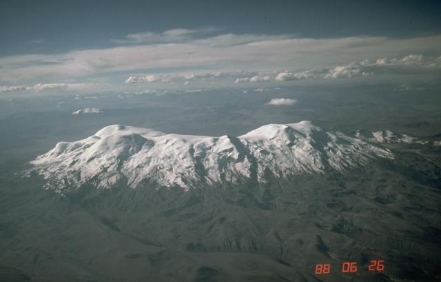
| 描述 | Aerial photo of Nevado Coropuna, Peru's largest and highest volcano, from the south. The true summit (left) is located at the NW end of the vast summit plateau. | |||
| 图中地点 | Southern Peru | |||
| 日期 | ||||
| 来源 | https://volcano.si.edu/volcano.cfm?vn=354003&vtab=Photos | |||
| 作者 | Norm Banks, U.S. Geological Survey | |||
| 授权 (二次使用本文件) |
|
文件历史
点击某个日期/时间查看对应时刻的文件。
| 日期/时间 | 缩略图 | 大小 | 用户 | 备注 | |
|---|---|---|---|---|---|
| 当前 | 2007年4月22日 (日) 04:25 | | 640 × 409(25 KB) | Seattle Skier | == Summary == {{Information |Description= Aerial photo of Nevado Coropuna, Peru's largest and highest volcano, from the south. The true summit (left) is located at the NW end of the vast summit plateau. |Source=http://www.volcano. |
文件用途
以下页面使用本文件:
全域文件用途
以下其他wiki使用此文件:
- ay.wikipedia.org上的用途
- be.wikipedia.org上的用途
- ca.wikipedia.org上的用途
- en.wikipedia.org上的用途
- lt.wikipedia.org上的用途
- qu.wikipedia.org上的用途
- uk.wikipedia.org上的用途