File:Dorcestriae Comitatus Vicinarumque Regionum nova veraq' Descriptio…. 1575.jpg

本预览的尺寸:800 × 566像素。 其他分辨率:320 × 226像素 | 640 × 453像素 | 1,024 × 725像素 | 1,280 × 906像素 | 2,560 × 1,812像素 | 4,765 × 3,372像素。
原始文件 (4,765 × 3,372像素,文件大小:4.27 MB,MIME类型:image/jpeg)
摘要
| 标题 |
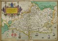
Latina: Dorcestriae Comitatus Vicinarumque Regionum nova veraq' Descriptio Anno Dni 1575 |
| 描写 |
English: Atlas created by cartographer Christopher Saxton in 1575 as part of his 'Atlas of the Counties of England and Wales'. |
| 日期 | |
| 来源 | This file has been provided by the University of Exeter, Special Collections. Image captured by University of Exeter Digital Humanities and taken from Dorcestriae Comitatus Vicinarumque Regionum nova veraq' Descriptio Anno Dni 1575; C Saxton's Atlas of England and Wales. |
| 创作作者 | |
| 荣誉行 | University of Exeter Special Collections |
| 授权 (二次使用本文件) |
CC0 |
| Geotemporal data | |
| 描绘日期 | |
| 地图位置 | Dorset |
| 地图类型 | County Map |
| 地理参考 | 如果不适当,请设置 warp_status = skip 为隐藏。 |
| Bibliographic data | |
| 出版物 |
Atlas of the Counties of England and Wales |
| 作者 | |
| 语言 | 拉丁语 |
| 出版地 | London |
| Archival data | |
| 馆藏 | University of Exeter Special Collections; Rare Books Collection. |
| 登录号 |
Rare books B 1590/SAX/XX |
| 尺寸 | 550mm x 430mm |
| 表现形式 | Printed; hand coloured. |
| 题记 | Christopherus Saxton descripsit. |
| 其他版本 |
|
许可协议
| 本作品采用知识共享CC0 1.0 通用公有领域贡献许可协议授权。 | |
| 采用本宣告发表本作品的人,已在法律允许的范围内,通过在全世界放弃其对本作品拥有的著作权法规定的所有权利(包括所有相关权利),将本作品贡献至公有领域。您可以复制、修改、传播和表演本作品,将其用于商业目的,无需要求授权。
|
文件历史
点击某个日期/时间查看对应时刻的文件。
| 日期/时间 | 缩略图 | 大小 | 用户 | 备注 | |
|---|---|---|---|---|---|
| 当前 | 2023年2月28日 (二) 16:37 | | 4,765 × 3,372(4.27 MB) | SnowballBearbear | Uploaded a work by Christopher Saxton from The University of Exeter Special Collections with UploadWizard |
文件用途
以下页面使用本文件:
全域文件用途
以下其他wiki使用此文件:
- en.wikipedia.org上的用途