File:Eifel - Deutsche Mittelgebirge, Serie A-de.png
本预览的尺寸:576 × 599像素。 其他分辨率:231 × 240像素 | 462 × 480像素 | 738 × 768像素 | 985 × 1,024像素 | 2,500 × 2,600像素。
原始文件 (2,500 × 2,600像素,文件大小:9.83 MB,MIME类型:image/png)
摘要
| 描述 |
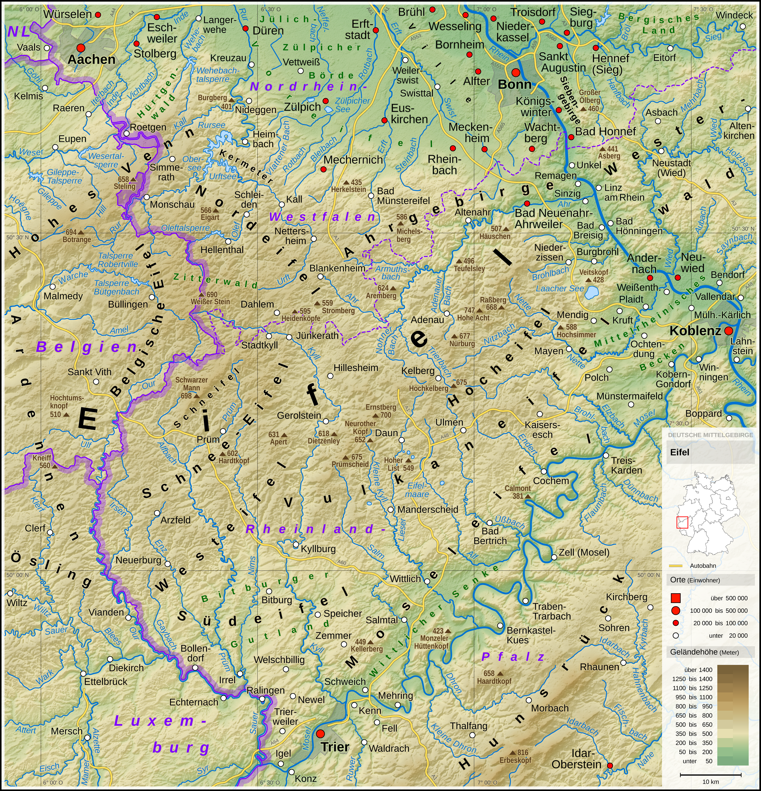
English: Topographic map of the Eifel
Deutsch: Topografische Karte der Eifel |
||||||||||||||||||
| 日期 | |||||||||||||||||||
| 来源 |
个人作品,使用: |
||||||||||||||||||
| 作者 | Thoroe | ||||||||||||||||||
| 其他版本 |
 Topographic maps of German low mountain ranges (A series)
This map series aims to show the major low mountain ranges of Germany in a uniform design. All maps are created on the same scale, and the background reliefs base upon the same color scheme. The reliefs are also available as separate files. You can find the making-of one of the maps in the German language Wikipedia (German only).
|
||||||||||||||||||


_-_Deutsche_Mittelgebirge,_Serie_A-de.png)
_-_Deutsche_Mittelgebirge,_Serie_A-de.png)
_-_Deutsche_Mittelgebirge,_Serie_A-de.png)
_-_Deutsche_Mittelgebirge,_Serie_A-de.png)
_-_Deutsche_Mittelgebirge,_Serie_A-de.png)
_-_Deutsche_Mittelgebirge,_Serie_A-de.png)
_-_Deutsche_Mittelgebirge,_Serie_A-de.png)
_-_Deutsche_Mittelgebirge,_Serie_A-de.png)
_-_Deutsche_Mittelgebirge,_Serie_A-de.png)
_-_Deutsche_Mittelgebirge,_Serie_A-de.png)
_-_Deutsche_Mittelgebirge,_Serie_A-de.png)
_-_Deutsche_Mittelgebirge,_Serie_A-de.png)
_-_Deutsche_Mittelgebirge,_Serie_A-de.png)
_-_Deutsche_Mittelgebirge,_Serie_A-de.png)
_-_Deutsche_Mittelgebirge,_Serie_A-de.png)
_-_Deutsche_Mittelgebirge,_Serie_A-de.png)
_-_Deutsche_Mittelgebirge,_Serie_A-de.png)
_-_Deutsche_Mittelgebirge,_Serie_A-de.png)
_-_Deutsche_Mittelgebirge,_Serie_A-de.png)
_-_Deutsche_Mittelgebirge,_Serie_A-de.png)
_-_Deutsche_Mittelgebirge,_Serie_A-de.png)
_-_Deutsche_Mittelgebirge,_Serie_A-de.png)
_-_Deutsche_Mittelgebirge,_Serie_A-de.png)
_-_Deutsche_Mittelgebirge,_Serie_A-de.png)
_-_Deutsche_Mittelgebirge,_Serie_A-de.png)
_-_Deutsche_Mittelgebirge,_Serie_A-de.png)
_-_Deutsche_Mittelgebirge,_Serie_A-de.png)
_-_Deutsche_Mittelgebirge,_Serie_A-de.png)
_-_Deutsche_Mittelgebirge,_Serie_A-de.png)
_-_Deutsche_Mittelgebirge,_Serie_A-de.png)
_-_Deutsche_Mittelgebirge,_Serie_A-de.png)
_-_Deutsche_Mittelgebirge,_Serie_A-de.png)
| This work contains information from OpenStreetMap, which is made available under the Open Database License (ODbL).
The ODbL does not require any particular license for maps produced from ODbL data. Prior to 1 August 2020, map tiles produced by the OpenStreetMap Foundation were licensed under the CC-BY-SA-2.0 license. Maps produced by other people may be subject to other licences. |

|
|
许可协议
本文件采用知识共享署名-相同方式共享 3.0 未本地化版本许可协议授权。
署名: Thomas Römer
- 您可以自由地:
- 共享 – 复制、发行并传播本作品
- 修改 – 改编作品
- 惟须遵守下列条件:
- 署名 – 您必须对作品进行署名,提供授权条款的链接,并说明是否对原始内容进行了更改。您可以用任何合理的方式来署名,但不得以任何方式表明许可人认可您或您的使用。
- 相同方式共享 – 如果您再混合、转换或者基于本作品进行创作,您必须以与原先许可协议相同或相兼容的许可协议分发您贡献的作品。
| 注解 | 该图片含有注解:在维基媒体共享资源上查看注解 |
文件历史
点击某个日期/时间查看对应时刻的文件。
| 日期/时间 | 缩略图 | 大小 | 用户 | 备注 | |
|---|---|---|---|---|---|
| 当前 | 2017年5月13日 (六) 10:53 | | 2,500 × 2,600(9.83 MB) | Thoroe | Brohlbach (Mosel) korr. |
| 2017年5月10日 (三) 23:05 |  | 2,500 × 2,600(9.82 MB) | Thoroe | + Stadtkyll | |
| 2017年5月7日 (日) 13:56 |  | 2,500 × 2,600(9.82 MB) | Thoroe | 1st revision | |
| 2017年5月4日 (四) 20:37 |  | 2,500 × 2,600(9.82 MB) | Thoroe | {{Information |Description ={{en|1=Topographic map of the Eifel}} {{de|1=Topografische Karte der Eifel}} |Source ={{Own using}} *[http://gmt.soest.hawaii.edu Generic Mapping Tools (GMT)] with [http://dds.cr.usgs.g... |
文件用途
以下页面使用本文件:
全域文件用途
以下其他wiki使用此文件:
- arz.wikipedia.org上的用途
- bn.wikipedia.org上的用途
- ca.wikipedia.org上的用途
- da.wikipedia.org上的用途
- de.wikipedia.org上的用途
- Eifel
- Vulkaneifel
- Wittlicher Senke
- Winterspelt (Andersch)
- Schneifel
- Östliche Hocheifel
- Ahrgebirge
- Rureifel
- Nordeifel
- Südeifel
- Zitterwald
- Portal:Eifel
- Kermeter
- Hürtgenwald (Forst)
- Wikipedia:Kartenwerkstatt/Kartenwünsche
- Moseleifel
- Liste von Bergen und Erhebungen der Eifel
- Voreifel
- Liste der naturräumlichen Einheiten in Rheinland-Pfalz
- Benutzer:Thoroe
- Bitburger Gutland
- Wikipedia:Kartenwerkstatt/Archiv/2017-05
- Prümscheid (Naturraum)
- Benutzer:Thoroe/Making of Thüringer Wald
- de.wiktionary.org上的用途
- el.wikipedia.org上的用途
- en.wikipedia.org上的用途
- en.wikivoyage.org上的用途
- eo.wikipedia.org上的用途
- es.wikipedia.org上的用途
- et.wikipedia.org上的用途
- fa.wikipedia.org上的用途
- fi.wikipedia.org上的用途
- frr.wikipedia.org上的用途
- fr.wikipedia.org上的用途
查看此文件的更多全域用途。