File:FHLB territory map.svg

此SVG文件的PNG预览的大小:800 × 495像素。 其他分辨率:320 × 198像素 | 640 × 396像素 | 1,024 × 633像素 | 1,280 × 791像素 | 2,560 × 1,583像素 | 959 × 593像素。
原始文件 (SVG文件,尺寸为959 × 593像素,文件大小:67 KB)
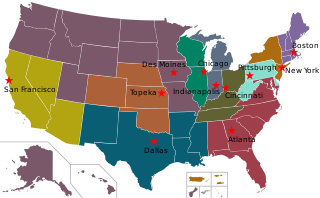
| 描述 | A map of the United States showing the twelve Federal Home Loan Bank territories and their headquarters. |
| 日期 | (UTC) |
| 来源 | |
| 作者 |
|
本文件采用知识共享署名-相同方式共享 3.0 未本地化版本许可协议授权。
- 您可以自由地:
- 共享 – 复制、发行并传播本作品
- 修改 – 改编作品
- 惟须遵守下列条件:
- 署名 – 您必须对作品进行署名,提供授权条款的链接,并说明是否对原始内容进行了更改。您可以用任何合理的方式来署名,但不得以任何方式表明许可人认可您或您的使用。
- 相同方式共享 – 如果您再混合、转换或者基于本作品进行创作,您必须以与原先许可协议相同或相兼容的许可协议分发您贡献的作品。
原始上传日志
This image is a derivative work of the following images:
- File:Blank_USA,_w_territories.svg licensed with Cc-by-sa-3.0-migrated, GFDL
- 2009-01-30T01:59:59Z Hoshie 959x593 (98189 Bytes) Reverted to version as of 23:58, 14 January 2009 - rv myself; DC can be seen clearly.
- 2009-01-18T23:34:42Z Hoshie 959x593 (102341 Bytes) Put DC in an inset; fixed Tutuila (American Samoa)
- 2009-01-14T23:58:05Z Lokal Profil 959x593 (98189 Bytes) Code cleanup and removed stroke from Guam and American Samoa
- 2009-01-13T05:19:51Z Hoshie 959x593 (101361 Bytes) re did Guam and added American Samoa
- 2007-12-02T16:08:45Z Lokal Profil 959x593 (88960 Bytes) {{Information |Description=A blank map of the United States including Puerto Rico, Guam, the United States Virgin Islands, and the Northern Mariana Islands. |Source=This version was made by [[:User:Lokal_Profil|Lokal_Profil]]
- File:Red_star.svg licensed with PD-shape
- 2011-02-08T18:58:07Z Sarang 1235x1175 (180 Bytes) more reduced code
- 2010-05-12T01:43:00Z Zscout370 1235x1175 (590 Bytes) Reduced code
- 2008-03-29T10:38:44Z F l a n k e r 1235x1175 (3615 Bytes) Geometries
- 2007-12-26T10:41:31Z Tobias Schmidbauer 190x181 (1478 Bytes) Reverted to version as of 09:44, 27 December 2005
- 2007-03-09T01:37:05Z Indolences 300x275 (350 Bytes)
- 2005-12-27T09:44:56Z Zscout370 190x181 (1478 Bytes) This was drawn by Tobias Schmidbauer.
- 2005-12-26T17:17:09Z Tobias Schmidbauer 190x181 (1473 Bytes) really better version
- 2005-12-24T02:06:13Z Zscout370 300x300 (773 Bytes) A generic red star.
Uploaded with derivativeFX
文件历史
点击某个日期/时间查看对应时刻的文件。
| 日期/时间 | 缩略图 | 大小 | 用户 | 备注 | |
|---|---|---|---|---|---|
| 当前 | 2018年5月31日 (四) 06:34 | | 959 × 593(67 KB) | SounderBruce | Updated to reflect merger of Seattle into Des Moines |
| 2011年4月26日 (二) 00:41 |  | 959 × 593(67 KB) | Gurch | test | |
| 2011年4月26日 (二) 00:34 |  | 959 × 593(68 KB) | Gurch | test | |
| 2011年4月26日 (二) 00:04 |  | 959 × 593(69 KB) | Sonia | {{Information |Description=A map of the United States showing the twelve Federal Home Loan Bank territories and their headquarters. |Source=*File:Blank_USA,_w_territories.svg *File:Red_star.svg |Date=2011-04-26 00:02 (UTC) |Author=* |
文件用途
以下页面使用本文件:
全域文件用途
以下其他wiki使用此文件:
- ar.wikipedia.org上的用途
- en.wikipedia.org上的用途
- ru.wikipedia.org上的用途