File:Fraser Island.png

本预览的尺寸:386 × 599像素。 其他分辨率:155 × 240像素 | 454 × 704像素。
原始文件 (454 × 704像素,文件大小:416 KB,MIME类型:image/png)
摘要
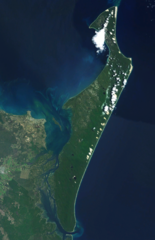
| 描述 | en:Fraser Island en:NASA World Wind en:Landsat montage. |
| 来源 | Satellite imagery taken from NASA World Wind software (by screenshot) |
| 作者 | 相片: NASA |
许可协议
| 本图像属于 w:公有领域 ,因其为 NASA 的 World Wind 卫星地图浏览器的一张截图,且使用了公有领域图层,如 Blue Marble、MODIS、Landsat、SRTM、USGS、GLOBE 等。
|
 |
原始上传日志
The original description page was here. All following user names refer to en.wikipedia.
- 2007-06-12 22:43 Aliasd 454×704×8 (425814 bytes) [[Fraser Island]] [[NASA World Wind]] [[Landsat]] montage. {{PD-NASA}}
文件历史
点击某个日期/时间查看对应时刻的文件。
| 日期/时间 | 缩略图 | 大小 | 用户 | 备注 | |
|---|---|---|---|---|---|
| 当前 | 2007年7月16日 (一) 18:14 | | 454 × 704(416 KB) | Finnrind | {{Information |Description=en:Fraser Island en:NASA World Wind en:Landsat montage. |Source=Originally from [http://en.wikipedia.org en.wikipedia]; description page is/was [http://en.wikipedia.org/w/index.php?title=Im |
文件用途
以下页面使用本文件:
全域文件用途
以下其他wiki使用此文件:
- ar.wikipedia.org上的用途
- ca.wikipedia.org上的用途
- cs.wikipedia.org上的用途
- da.wikipedia.org上的用途
- de.wikipedia.org上的用途
- en.wikipedia.org上的用途
- et.wikipedia.org上的用途
- fa.wikipedia.org上的用途
- gl.wikipedia.org上的用途
- mt.wikipedia.org上的用途
- pl.wikipedia.org上的用途
- pt.wikipedia.org上的用途
- sh.wikipedia.org上的用途
- www.wikidata.org上的用途