File:FrontLines Environment Photo Contest Winner -5 (5808476109).jpg
本预览的尺寸:800 × 534像素。 其他分辨率:320 × 214像素 | 640 × 427像素 | 1,024 × 683像素 | 1,280 × 854像素。
原始文件 (1,280 × 854像素,文件大小:432 KB,MIME类型:image/jpeg)
.jpg?uselang=zh-cn)
.jpg?uselang=zh-cn)
.jpg?action=history&uselang=zh-cn)
.jpg)
摘要
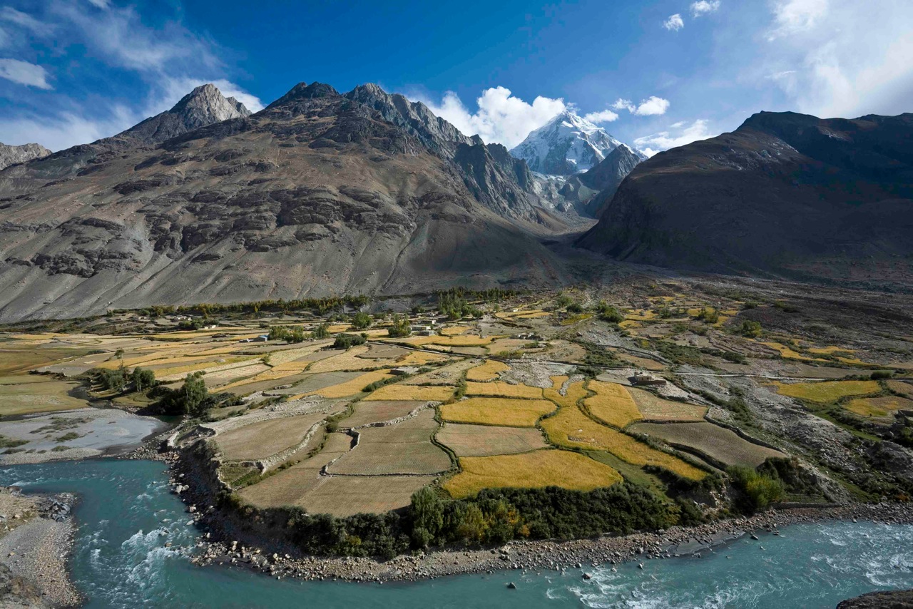
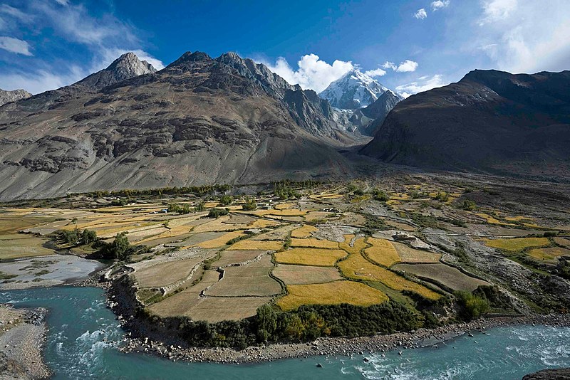
| 描述 | Here, a dramatic view of flood plain cultivation in Wakhan, Afghanistan. Known as "the roof of the world," the Wildlife Conservation Society says the Wakhan Corridor has few rivals in terms of scenic beauty. The little-known area is nestled in the high Pamir Mountains and the region is flanked by the Hindu Kush, Himalayn, Karakoram, and Kunlun ranges. Credit: John Winnie Jr., WCS-Afghanistan |
| 日期 | |
| 来源 | FrontLines Environment Photo Contest Winner #5 |
| 作者 | USAID U.S. Agency for International Development |
| 相机位置 | | 在以下服务上查看本图像和附近其他图像: OpenStreetMap |
|---|
.jpg¶ms=036.952778_N_0072.962500_E_globe:Earth_type:camera__&language=zh-cn)
| 物体位置 | | 在以下服务上查看本图像和附近其他图像: OpenStreetMap |
|---|
.jpg¶ms=036.951111_N_0072.962778_E_globe:Earth_class:object_type:object__&language=zh-cn)
- Notes on location estimate
- Identify village by shape of the farm field
许可协议
This image is a work of a United States Agency for International Development employee, taken or made as part of that person's official duties. As a work of the U.S. federal government, the image is in the public domain in the United States.
See also: The USAID privacy policy and the USAID Office of Inspector General "Disclaimers & Notices" page
|
 |
| 这幅图片原始出处为Flickr的https://flickr.com/photos/46658241@N06/5808476109 ,作者为USAID_IMAGES 。经机器人FlickreviewR在2017年1月4日审查后确定为采用United States Government Work的协议授权使用。 |
文件历史
点击某个日期/时间查看对应时刻的文件。
| 日期/时间 | 缩略图 | 大小 | 用户 | 备注 | |
|---|---|---|---|---|---|
| 当前 | 2017年1月4日 (三) 02:06 | | 1,280 × 854(432 KB) | Reguyla | Transferred from Flickr via Flickr2Commons |
文件用途
以下页面使用本文件:
全域文件用途
以下其他wiki使用此文件:
- arz.wikipedia.org上的用途
- be.wikipedia.org上的用途
- bg.wikipedia.org上的用途
- ca.wikipedia.org上的用途
- ceb.wikipedia.org上的用途
- cs.wikipedia.org上的用途
- de.wikipedia.org上的用途
- de.wikivoyage.org上的用途
- el.wikipedia.org上的用途
- en.wikipedia.org上的用途
- en.wikivoyage.org上的用途
- eo.wikipedia.org上的用途
- es.wikipedia.org上的用途
- eu.wikipedia.org上的用途
- fa.wikipedia.org上的用途
- he.wikivoyage.org上的用途
- ja.wikipedia.org上的用途
- pl.wikipedia.org上的用途
- pl.wiktionary.org上的用途
- ru.wikipedia.org上的用途
- ru.wikinews.org上的用途
- sv.wikipedia.org上的用途
- ta.wikipedia.org上的用途
- uk.wikipedia.org上的用途
- ur.wikipedia.org上的用途
- www.wikidata.org上的用途
.jpg)