File:GökturksAD551-572.png

本预览的尺寸:800 × 467像素。 其他分辨率:320 × 187像素 | 640 × 373像素 | 1,024 × 597像素 | 1,644 × 959像素。
原始文件 (1,644 × 959像素,文件大小:28 KB,MIME类型:image/png)
摘要
| 描述 |
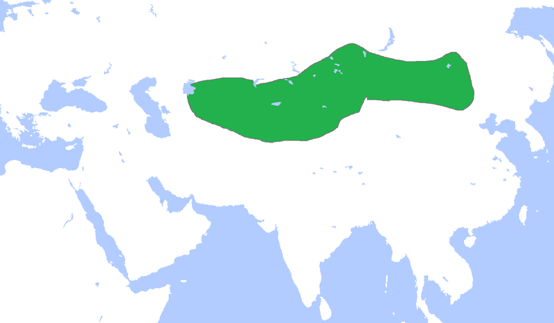
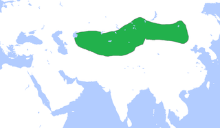
English: Locator map of the Gökturks, c. 551-572.
(Partially based on Atlas of World History (2007) - The World 500-750, map) |
| 日期 | |
| 来源 | 自己的作品 |
| 作者 | Gabagool |
许可协议
我,本作品著作权人,特此采用以下许可协议发表本作品:
本文件采用知识共享署名 3.0 未本地化版本许可协议授权。
- 您可以自由地:
- 共享 – 复制、发行并传播本作品
- 修改 – 改编作品
- 惟须遵守下列条件:
- 署名 – 您必须对作品进行署名,提供授权条款的链接,并说明是否对原始内容进行了更改。您可以用任何合理的方式来署名,但不得以任何方式表明许可人认可您或您的使用。
文件历史
点击某个日期/时间查看对应时刻的文件。
| 日期/时间 | 缩略图 | 大小 | 用户 | 备注 | |
|---|---|---|---|---|---|
| 当前 | 2021年3月18日 (四) 14:36 | | 1,644 × 959(28 KB) | HistoryofIran | rv, user is banned |
| 2021年3月18日 (四) 14:08 |  | 1,644 × 959(54 KB) | TurkicHeritage | Reverted to version as of 12:36, 18 March 2021 (UTC) | |
| 2021年3月18日 (四) 12:43 |  | 1,644 × 959(28 KB) | HistoryofIran | rv, vandalism | |
| 2021年3月18日 (四) 12:36 |  | 1,644 × 959(54 KB) | HistoryofHumann | Reverted to the original uploaded version. Changes without valid source will be reverted. | |
| 2021年3月18日 (四) 01:30 |  | 1,644 × 959(28 KB) | HistoryofIran | Reverted to version as of 10:51, 26 July 2013 (UTC) | |
| 2021年3月16日 (二) 23:17 |  | 1,644 × 959(54 KB) | HistoryofHumann | This version is the correct one. The changes are based on most reliable sources | |
| 2013年7月26日 (五) 10:51 |  | 1,644 × 959(28 KB) | HistoryofIran | Fixed map borders, they never controlled so much land down south. | |
| 2009年4月23日 (四) 15:37 |  | 1,644 × 959(54 KB) | Gabagool | {{Information |Description={{en|1=Locator map of the Gökturks, c. 551-572. (Partially based on ''Atlas of World History'' (2007) - The World 500-750, map)}} |Source=Own work by uploader |Author=Gabagool / Jarle Grøhn |Date=2009-04-23 |
文件用途
全域文件用途
以下其他wiki使用此文件:
- ar.wikipedia.org上的用途
- ast.wikipedia.org上的用途
- azb.wikipedia.org上的用途
- az.wikipedia.org上的用途
- ba.wikipedia.org上的用途
- de.wikipedia.org上的用途
- el.wikipedia.org上的用途
- en.wikipedia.org上的用途
- es.wikipedia.org上的用途
- fa.wikipedia.org上的用途
- fi.wikipedia.org上的用途
- fr.wikipedia.org上的用途
- hi.wikipedia.org上的用途
- hr.wikipedia.org上的用途
- hu.wikipedia.org上的用途
- hy.wikipedia.org上的用途
- id.wikipedia.org上的用途
- id.wikibooks.org上的用途
- it.wikipedia.org上的用途
- ja.wikipedia.org上的用途
- ko.wikipedia.org上的用途
查看本文件的更多全域用途。