File:Grytviken-Location.jpg

本预览的尺寸:800 × 560像素。 其他分辨率:320 × 224像素 | 640 × 448像素 | 1,024 × 717像素 | 1,280 × 896像素 | 2,165 × 1,516像素。
原始文件 (2,165 × 1,516像素,文件大小:1.48 MB,MIME类型:image/jpeg)
摘要
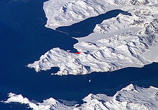
English: Satellite image of central South Georgia Island - in the Antarctic region.
- View of Cumberland Bay area, South Georgia Island: Thatcher Peninsula with King Edward Cove and Grytviken (red).
- Credits
- Fragment made by Apcbg.
- Image
- Science and Analysis Laboratory, NASA-Johnson Space Center. 25 Mar. 2005. "Astronaut Photography of Earth - Display Record."[1]
Source URL
许可协议
| 本文件完全由NASA创作,在美国属于公有领域。根据NASA的版权方针,NASA的材料除非另有声明否则不受版权保护。(参见Template:PD-USGov/zh、NASA版权方针页面或JPL图片使用方针。) | ||
 |
警告:
|
文件历史
点击某个日期/时间查看对应时刻的文件。
| 日期/时间 | 缩略图 | 大小 | 用户 | 备注 | |
|---|---|---|---|---|---|
| 当前 | 2007年10月1日 (一) 09:19 | | 2,165 × 1,516(1.48 MB) | Apcbg | == Summary == Satellite image of Cumberland Bay area, South Georgia Island: Thatcher Peninsula with King Edward Cove and Grytviken. Fragment made by Apcbg. Image Science and Analysis Laboratory, NASA-Johnson Space Center. 25 Mar. 2005. "Astronaut Photog |
| 2006年5月27日 (六) 10:32 |  | 2,093 × 1,495(1.18 MB) | Apcbg | Satellite image of Cumberland Bay area, South Georgia Island: Thatcher Peninsula with King Edward Cove and Grytviken. Fragment made by Apcbg. Image Science and Analysis Laboratory, NASA-Johnson Space Center. 25 Mar. 2005. "Astronaut Photography of Earth |
文件用途
以下页面使用本文件:
全域文件用途
以下其他wiki使用此文件:
- ang.wikipedia.org上的用途
- ar.wikipedia.org上的用途
- ast.wikipedia.org上的用途
- az.wikipedia.org上的用途
- bg.wikipedia.org上的用途
- ca.wikipedia.org上的用途
- ckb.wikipedia.org上的用途
- en.wikipedia.org上的用途
- es.wikipedia.org上的用途
- fa.wikipedia.org上的用途
- hr.wikipedia.org上的用途
- id.wikipedia.org上的用途
- it.wikipedia.org上的用途
- lad.wikipedia.org上的用途
- ms.wikipedia.org上的用途
- nl.wikipedia.org上的用途
- nn.wikipedia.org上的用途
- no.wikipedia.org上的用途
- ru.wikipedia.org上的用途
- sh.wikipedia.org上的用途
- sk.wikipedia.org上的用途
- sr.wikipedia.org上的用途
- sv.wikipedia.org上的用途
- ta.wikipedia.org上的用途
- th.wikipedia.org上的用途
- uk.wikipedia.org上的用途