File:Hawaii Island topographic map-en.svg

此SVG文件的PNG预览的大小:728 × 600像素。 其他分辨率:291 × 240像素 | 583 × 480像素 | 932 × 768像素 | 1,243 × 1,024像素 | 2,485 × 2,048像素 | 3,110 × 2,563像素。
原始文件 (SVG文件,尺寸为3,110 × 2,563像素,文件大小:2.12 MB)
摘要
| 描述 |
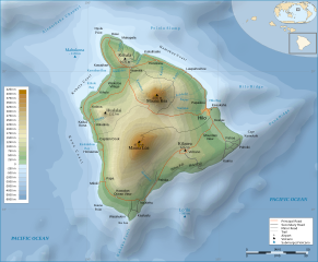
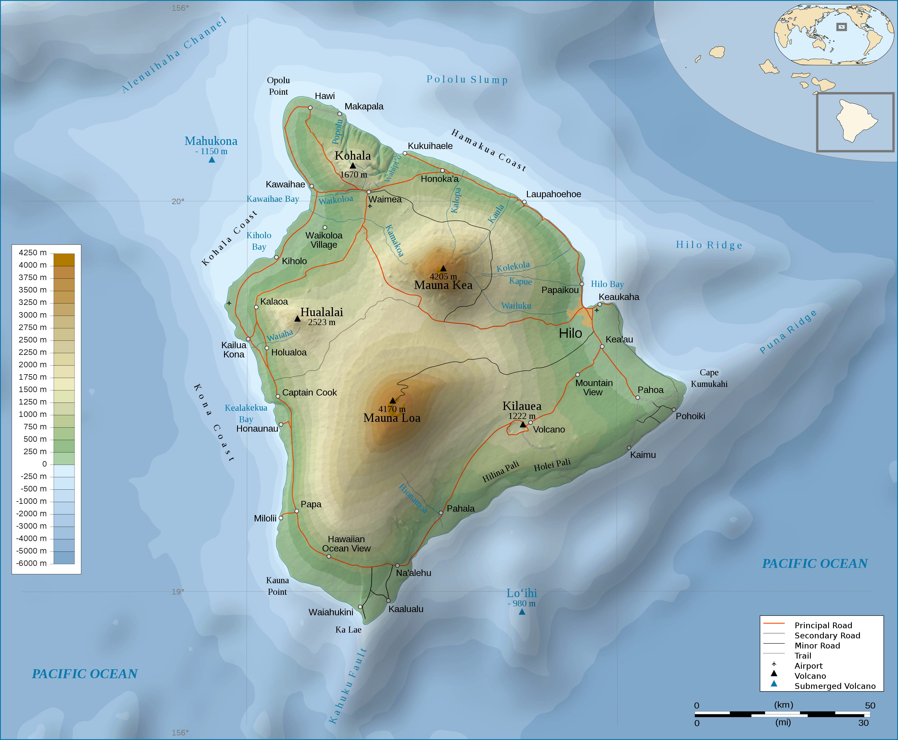
English: Topographic Map in english of the island of Hawaii. |
| 日期 | (UTC) |
| 来源 | |
| 作者 |
|
| 其他版本 |
[]
|


许可协议
本文件采用知识共享署名-相同方式共享 3.0 未本地化版本许可协议授权。
- 您可以自由地:
- 共享 – 复制、发行并传播本作品
- 修改 – 改编作品
- 惟须遵守下列条件:
- 署名 – 您必须对作品进行署名,提供授权条款的链接,并说明是否对原始内容进行了更改。您可以用任何合理的方式来署名,但不得以任何方式表明许可人认可您或您的使用。
- 相同方式共享 – 如果您再混合、转换或者基于本作品进行创作,您必须以与原先许可协议相同或相兼容的许可协议分发您贡献的作品。
原始上传日志
This image is a derivative work of the following images:
- File:Hawaii_Island_topographic_map-fr.svg licensed with Cc-by-sa-3.0,2.5,2.0,1.0, GFDL
- 2009-02-16T12:24:40Z Sémhur 3110x2563 (2213946 Bytes) Valid SVG
- 2008-05-07T17:31:00Z Sémhur 3110x2563 (2292418 Bytes) Route coupée trop courte, je rallonge.
- 2008-05-02T17:57:22Z Sémhur 3110x2563 (2290853 Bytes) Suppression d'une partie d'une route détruite par une coulée de lave
- 2008-05-01T10:37:28Z Sémhur 3110x2563 (2290359 Bytes) New version, with vectorized shaded relief
- 2008-04-29T18:35:04Z Sting 3110x2563 (1041004 Bytes) Slight correction
- 2008-04-29T18:11:00Z Sting 3110x2563 (1041493 Bytes) Added legend
- 2008-04-22T16:01:56Z Sémhur 3110x2563 (1036030 Bytes) Espacement de lettres (oubli)
- 2008-04-19T08:45:11Z Sémhur 3110x2563 (1034767 Bytes) Correction de l'altitude du Mauna Loa et espacement de lettres
- 2008-04-17T19:04:48Z Sémhur 3110x2563 (1019305 Bytes) Correction d'un problème avec le relief
- 2008-04-17T18:47:58Z Sémhur 3110x2563 (1019765 Bytes) == Description == {{Information |Description= {{en| Topographic Map in french of the island of [[:en:Hawaii (Island)|Hawaii]].}} {{fr| Carte topographique de l'île de [[:fr:Hawaii|Hawaii]].}} |Source=Travail personnel. {{clr
Uploaded with derivativeFX
文件历史
点击某个日期/时间查看对应时刻的文件。
| 日期/时间 | 缩略图 | 大小 | 用户 | 备注 | |
|---|---|---|---|---|---|
| 当前 | 2009年3月3日 (二) 22:56 | | 3,110 × 2,563(2.12 MB) | Kmusser | attempted legend fix |
| 2009年3月3日 (二) 22:54 |  | 3,110 × 2,563(2.12 MB) | Kmusser | attempted legend fix | |
| 2009年3月3日 (二) 22:49 |  | 3,110 × 2,563(2.12 MB) | Kmusser | legend fix | |
| 2009年3月3日 (二) 22:06 |  | 3,110 × 2,563(2.12 MB) | Kmusser | {{Information |Description={{Topographic Map in english of the island of Hawaii.}} |Source=*File:Hawaii_Island_topographic_map-fr.svg |Date=2009-03-03 22:04 (UTC) |Author=*File:Hawaii_Island_topographic_map-fr.svg: [[Us |
文件用途
以下页面使用本文件:
全域文件用途
以下其他wiki使用此文件:
- af.wikipedia.org上的用途
- cy.wikipedia.org上的用途
- de.wikipedia.org上的用途
- el.wikipedia.org上的用途
- en.wikipedia.org上的用途
- eo.wikipedia.org上的用途
- fa.wikipedia.org上的用途
- fr.wikipedia.org上的用途
- fy.wikipedia.org上的用途
- hr.wikipedia.org上的用途
- ja.wikipedia.org上的用途
- ka.wikipedia.org上的用途
- nl.wikipedia.org上的用途
- pl.wikipedia.org上的用途
- tr.wikipedia.org上的用途