File:Hercynides EN.svg

此SVG文件的PNG预览的大小:550 × 370像素。 其他分辨率:320 × 215像素 | 640 × 431像素 | 1,024 × 689像素 | 1,280 × 861像素 | 2,560 × 1,722像素。
原始文件 (SVG文件,尺寸为550 × 370像素,文件大小:108 KB)
摘要
| 描述 |
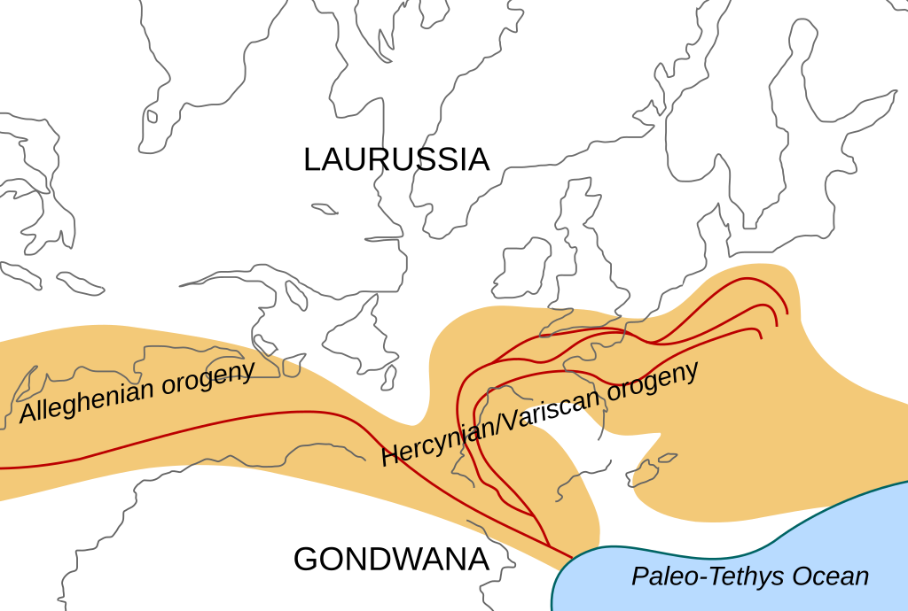
English: Location of the Hercynian/Variscan/Alleghanian mountain chains in the middle of the Carboniferous period. Present day coastlines are shown for reference. Red lines are sutures, capitalized names are the different continents that joined during these orogenies.
Literature used to make this map:
|
| 日期 | |
| 来源 | 自己的作品 |
| 作者 | Woudloper |
| 其他版本 |
Derivative works of this file: Image:Hercynides NL.svg, Image:Hercynides DE.svg, Image:Hercynides IT.svg |

|
This SVG file contains embedded text that can be translated into your language, using any capable SVG editor, text editor or the SVG Translate tool. For more information see: About translating SVG files. |
许可协议
本文件采用知识共享署名-相同方式共享 1.0 通用许可协议授权。
- 您可以自由地:
- 共享 – 复制、发行并传播本作品
- 修改 – 改编作品
- 惟须遵守下列条件:
- 署名 – 您必须对作品进行署名,提供授权条款的链接,并说明是否对原始内容进行了更改。您可以用任何合理的方式来署名,但不得以任何方式表明许可人认可您或您的使用。
- 相同方式共享 – If you alter, transform, or build upon this work, you must distribute the resulting work under the same license as the original.
文件历史
点击某个日期/时间查看对应时刻的文件。
| 日期/时间 | 缩略图 | 大小 | 用户 | 备注 | |
|---|---|---|---|---|---|
| 当前 | 2008年12月2日 (二) 19:29 | | 550 × 370(108 KB) | Woudloper | {{Information |Description={{en|1=Location of the Hercynian/Variscan/Alleghanian mountain chains in the middle of the Carboniferous period. Present day coastlines are shown for reference. Red lines are sutures, capitalized names are the different continen |
文件用途
全域文件用途
以下其他wiki使用此文件:
- ca.wikipedia.org上的用途
- en.wikipedia.org上的用途
- fa.wikipedia.org上的用途
- fr.wikipedia.org上的用途
- gl.wikipedia.org上的用途
- nn.wikipedia.org上的用途
- pl.wikipedia.org上的用途
- ro.wikipedia.org上的用途
- tr.wikipedia.org上的用途