File:IntertropicalConvergenceZone-EO.jpg

原始文件 (2,772 × 1,250像素,文件大小:1.54 MB,MIME类型:image/jpeg)
摘要
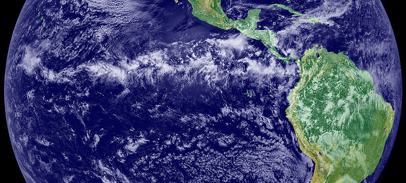
The Intertropical Convergence Zone (ITCZ), is the region that circles the Earth, near the equator, where the trade winds of the Northern and Southern Hemispheres come together. The intense sun and warm water of the equator heats the air in the ITCZ, raising its humidity and causing it to rise. As the air rises it cools, releasing the accumulated moisture in an almost perpetual series of thunderstorms.
Variation in the location of the ITCZ drastically affects rainfall in many equatorial nations, resulting in the wet and dry seasons of the tropics rather than the cold and warm seasons of higher latitudes. Longer term changes in the ITCZ can result in severe droughts or flooding in nearby areas.
Credit/source
This image is a combination of cloud data from NOAA’s newest Geostationary Operational Environmental Satellite (GOES-11) and color land cover classification data. The ITCZ is the band of bright white clouds that cuts across the center of the image.
http://earthobservatory.nasa.gov/IOTD/view.php?id=703
许可协议
| 本文件完全由NASA创作,在美国属于公有领域。根据NASA的版权方针,NASA的材料除非另有声明否则不受版权保护。(参见Template:PD-USGov/zh、NASA版权方针页面或JPL图片使用方针。) | ||
 |
警告:
|
文件历史
点击某个日期/时间查看对应时刻的文件。
| 日期/时间 | 缩略图 | 大小 | 用户 | 备注 | |
|---|---|---|---|---|---|
| 当前 | 2005年6月12日 (日) 17:45 | | 2,772 × 1,250(1.54 MB) | Gustavo Carrancio~commonswiki | Pic from http://earthobservatory.nasa.gov/Newsroom/NewImages/images.php3?img_id=4028 File history Nasa photo with no especific Copyright |
文件用途
以下页面使用本文件:
全域文件用途
以下其他wiki使用此文件:
- bh.wikipedia.org上的用途
- bn.wikipedia.org上的用途
- ca.wikipedia.org上的用途
- cs.wikipedia.org上的用途
- da.wikipedia.org上的用途
- de.wikipedia.org上的用途
- el.wikipedia.org上的用途
- en.wikipedia.org上的用途
- en.wikibooks.org上的用途
- en.wikiversity.org上的用途
- en.wiktionary.org上的用途
- es.wikipedia.org上的用途
- fa.wikipedia.org上的用途
- fi.wikipedia.org上的用途
- fr.wikipedia.org上的用途
- fr.wikinews.org上的用途
- ga.wikipedia.org上的用途
- ha.wikipedia.org上的用途
- he.wikipedia.org上的用途
- hi.wikipedia.org上的用途
- id.wikipedia.org上的用途
- ig.wikipedia.org上的用途
- ja.wikipedia.org上的用途
- ko.wikipedia.org上的用途
- ko.wiktionary.org上的用途
- mk.wikipedia.org上的用途
- nl.wikipedia.org上的用途
- nn.wikipedia.org上的用途
- no.wikipedia.org上的用途
- oc.wikipedia.org上的用途
查看本文件的更多全域用途。