File:Isaberrysaura map.jpg

本预览的尺寸:691 × 600像素。 其他分辨率:276 × 240像素 | 553 × 480像素 | 926 × 804像素。
原始文件 (926 × 804像素,文件大小:232 KB,MIME类型:image/jpeg)
文件历史
点击某个日期/时间查看对应时刻的文件。
| 日期/时间 | 缩略图 | 大小 | 用户 | 备注 | |
|---|---|---|---|---|---|
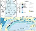
| 当前 | 2017年2月21日 (二) 18:40 |  | 926 × 804(232 KB) | FunkMonk | =={{int:filedesc}}== {{Information |description=Geological map showing the type locality of Isaberrysaura mollensis gen. et sp. nov. The map was made by Alberto C. Garrido on the basis of a LANDSAT satellite image available in the Dirección Provincial... |
文件用途
以下页面使用本文件:
全域文件用途
以下其他wiki使用此文件:
- en.wikipedia.org上的用途
- es.wikipedia.org上的用途
- it.wikipedia.org上的用途
- nl.wikipedia.org上的用途
- www.wikidata.org上的用途
