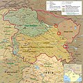
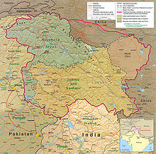
File:Kashmir Region (2020 skirmish locations).jpg

本预览的尺寸:604 × 599像素。 其他分辨率:242 × 240像素 | 484 × 480像素 | 774 × 768像素 | 1,033 × 1,024像素 | 1,579 × 1,566像素。
原始文件 (1,579 × 1,566像素,文件大小:1.27 MB,MIME类型:image/jpeg)
文件历史
点击某个日期/时间查看对应时刻的文件。
| 日期/时间 | 缩略图 | 大小 | 用户 | 备注 | |
|---|---|---|---|---|---|
| 当前 | 2020年6月24日 (三) 18:45 |  | 1,579 × 1,566(1.27 MB) | MarkH21 | Removed the Daulat Beg Oldi circle as not being an actual location of conflict; added the Hot Springs, Chang Chenmo Valley circle as an actual location of conflict. |
| 2020年6月24日 (三) 02:01 |  | 1,579 × 1,566(1.27 MB) | MarkH21 | Uploaded a work by United States Central Intelligence Agency, MarkH21 from [https://legacy.lib.utexas.edu/maps/middle_east_and_asia/kashmir_region_2004.jpg Map of Kashmir region] created by the US Central Intelligence Agency, 2004; altered by MarkH21 with UploadWizard |
文件用途
以下页面使用本文件:
全域文件用途
以下其他wiki使用此文件:
- af.wikipedia.org上的用途
- ca.wikipedia.org上的用途
- en.wikipedia.org上的用途
- es.wikipedia.org上的用途
- fa.wikipedia.org上的用途
- fr.wikipedia.org上的用途
- he.wikipedia.org上的用途
- ja.wikipedia.org上的用途
- ka.wikipedia.org上的用途
- ml.wikipedia.org上的用途
- ne.wikipedia.org上的用途
- pnb.wikipedia.org上的用途
- pt.wikipedia.org上的用途
- ru.wikipedia.org上的用途
- simple.wikipedia.org上的用途
- so.wikipedia.org上的用途
- ta.wikipedia.org上的用途
- te.wikipedia.org上的用途
- th.wikipedia.org上的用途
- tr.wikipedia.org上的用途
- uk.wikipedia.org上的用途
- ur.wikipedia.org上的用途
- vi.wikipedia.org上的用途
- www.wikidata.org上的用途


