File:LRO Tycho Central Peak 0.25.jpg

原始文件 (5,400 × 2,480像素,文件大小:4.52 MB,MIME类型:image/jpeg


摘要

描述
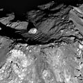
English: On 10 June 2011 the LRO spacecraft slewed 65° to the west, allowing the LROC NACs to capture this dramatic sunrise view of Tycho crater. A very popular target with amateur astronomers, Tycho is located at 43.37°S, 348.68°E, and is ~82 km (51 miles) in diameter. The summit of the central peak is 2 km (6562 ft) above the crater floor, and the crater floor is about 4700 m (15,420 ft) below the rim. Many "clasts" ranging in size from 10 meters to 100s of meters are exposed in the central peak slopes. Were these distinctive outcrops formed as a result of crushing and deformation of the target rock as the peak grew? Or do they represent preexisting rock layers that were brought intact to the surface? Imagine future geologists carefully making their way across these steep slopes, sampling a diversity of rocks brought up from depth. Tycho's features are so steep and sharp because the crater is young by lunar standards, only about 110 million years old. Over time, micrometeorites, and not so micro meteorites, will grind and erode these steep slopes into smooth mountains. For a preview of what Tycho's central peak may look like in a few billion years, visit Bhabha crater.

This is a version with about one fourth the linear pixel density of the original NASA full size image.
日期
来源 http://lroc.sese.asu.edu/news/?archives/411-Tycho-Central-Peak-Spectacular!.html (downloaded TIFF file from http://wms.lroc.asu.edu/lroc_browse/view/M162350671)
作者 NASA / GSFC / Arizona State University
其他版本

许可协议

Public domain 本文件完全由NASA创作,在美国属于公有领域。根据NASA的版权方针,NASA的材料除非另有声明否则不受版权保护。(参见Template:PD-USGov/zhNASA版权方针页面JPL图片使用方针。)
警告:

说明

添加一行文字以描述该文件所表现的内容

此文件中描述的项目

描绘内容

文件历史

点击某个日期/时间查看对应时刻的文件。

日期/时间缩⁠略⁠图大小用户备注
当前2013年1月6日 (日) 10:552013年1月6日 (日) 10:55版本的缩略图5,400 × 2,480(4.52 MB)WolfmanSFUser created page with UploadWizard

以下页面使用本文件:

全域文件用途

以下其他wiki使用此文件:

元数据