File:Maas memel etsch belt.svg

此SVG文件的PNG预览的大小:650 × 600像素。 其他分辨率:260 × 240像素 | 520 × 480像素 | 832 × 768像素 | 1,109 × 1,024像素 | 2,219 × 2,048像素 | 1,300 × 1,200像素。
原始文件 (SVG文件,尺寸为1,300 × 1,200像素,文件大小:608 KB)
摘要
Description - Beschreibung
| 描述 |
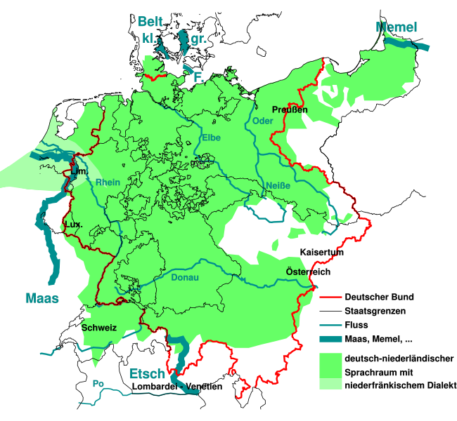
English: The German national anthem Deutschlandlied was written in 1841, giving four water bodies as borders of the German language Sprachraum of the time "Von der Maas bis an die Memel, von der Etsch bis an den Belt". This maps outlines them, and the border of the German Confederation of the time.
Deutsch: "Von der Maas bis an die Memel, von der Etsch bis an den Belt", die 4 "Grenzen" aus dem Deutschlandlied im geographisch-historischen Kontext von 1841:
Die Grenzen wurden der Karte auf der Seite Deutscher Bund entnommen und auf den Zustand 1841 vereinfacht. Die Sprachverteilung wurde stark vereinfacht aus einer Karte der Seite Deutsche Sprache entnommen und gibt den Zustand von 1910 wieder, der sich aber vermutlich nicht so stark von 1841 unterscheidet. Sie soll nur grobe Zusammenhänge zwischen damaliger Sprachverteilung zu den damaligen Grenzen aufzeigen. |
| 日期 | |
| 来源 | like File:Map-DB-Frankfurt.svg from http://www.ieg-maps.uni-mainz.de, and: File:Deutscher Bund.png, File:Historisches deutsches Sprachgebiet.PNG, File:Continental West Germanic languages.png |
| 作者 | Mueck |
| 其他版本 | |
| SVG开发 |


.svg)
许可协议
我,本作品著作权人,特此采用以下许可协议发表本作品:

|
已授权您依据自由软件基金会发行的无固定段落及封面封底文字(Invariant Sections, Front-Cover Texts, and Back-Cover Texts)的GNU自由文件许可协议1.2版或任意后续版本的条款,复制、传播和/或修改本文件。该协议的副本请见“GNU Free Documentation License”。 |
本文件采用知识共享署名 3.0 未本地化版本许可协议授权。
- 您可以自由地:
- 共享 – 复制、发行并传播本作品
- 修改 – 改编作品
- 惟须遵守下列条件:
- 署名 – 您必须对作品进行署名,提供授权条款的链接,并说明是否对原始内容进行了更改。您可以用任何合理的方式来署名,但不得以任何方式表明许可人认可您或您的使用。
您可以选择您需要的许可协议。
文件历史
点击某个日期/时间查看对应时刻的文件。
| 日期/时间 | 缩略图 | 大小 | 用户 | 备注 | |
|---|---|---|---|---|---|
| 当前 | 2023年8月11日 (五) 02:33 | | 1,300 × 1,200(608 KB) | Amlz | Reverted to version as of 13:07, 30 May 2017 (UTC) to correct weird vector artifacts |
| 2017年7月22日 (六) 01:00 |  | 1,301 × 1,201(652 KB) | AKAKIOS | Removed the Dutch speaking area and left only the Dutch/Low Frankish dialects in modern Germany. To add the Netherlands and Flanders to this map is inaccurate, both in its contemporary and historical context. | |
| 2017年5月30日 (二) 13:07 |  | 1,300 × 1,200(608 KB) | Mueck | Reverted to version as of 19:16, 27 January 2011 (UTC) Indeed: Correctomundo~commonswiki produced bad quality, autotraced (or some other bad technic ...) and content: the "historic continuum" is just the interesting thing in this map ... | |
| 2014年8月12日 (二) 00:03 |  | 1,301 × 1,201(652 KB) | Correctomundo~commonswiki | Fixed. | |
| 2014年8月11日 (一) 23:55 |  | 1,300 × 1,200(608 KB) | Correctomundo~commonswiki | Same problem. | |
| 2014年8月11日 (一) 23:55 |  | 1,300 × 1,200(608 KB) | Correctomundo~commonswiki | Same problem. | |
| 2014年8月11日 (一) 23:54 |  | 1,625 × 1,500(241 KB) | Correctomundo~commonswiki | Color correction. | |
| 2014年8月11日 (一) 23:53 |  | 1,300 × 1,200(608 KB) | Correctomundo~commonswiki | something went wrong with the colours | |
| 2014年8月11日 (一) 23:53 |  | 1,625 × 1,500(57 KB) | Correctomundo~commonswiki | Removed Dutch and Standard Dutch influenced dialects. These are not German dialects, even though there historically was a continuum. | |
| 2011年1月27日 (四) 19:16 |  | 1,300 × 1,200(608 KB) | NordNordWest | c |
文件用途
以下页面使用本文件:
全域文件用途
以下其他wiki使用此文件:
- az.wikipedia.org上的用途
- cs.wikipedia.org上的用途
- de.wikipedia.org上的用途
- en.wikipedia.org上的用途
- fi.wikipedia.org上的用途
- fr.wikipedia.org上的用途
- ka.wikipedia.org上的用途
- ko.wikipedia.org上的用途
- sr.wikipedia.org上的用途
- zh-yue.wikipedia.org上的用途