File:Map of the town of Michigan 1847.jpg

本预览的尺寸:800 × 458像素。 其他分辨率:320 × 183像素 | 640 × 366像素 | 1,024 × 586像素 | 1,280 × 732像素 | 2,560 × 1,465像素 | 11,430 × 6,540像素。
原始文件 (11,430 × 6,540像素,文件大小:48.27 MB,MIME类型:image/jpeg)
摘要
| 描述 |
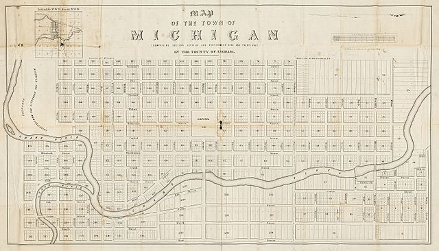
English: Map of the town of Michigan : (comprising section sixteen and portions of nine and twenty one) in the county of Ingham / surveyed by T. McCracken.
Originally published: N[ew] Y[ork] : Miller's Lith., [1847] An 1847 plat map of Lansing, Michigan, oriented with north to the right, with the name of the city given as "the town of Michigan," prior to the Michigan Legislature's establishment of the city's name as "Lansing" in 1848. Many of the street names are still in use. The area at the left (south) labeled "Reserved for hydraulic and manufacturing purposes" would later be the site of the Grand River Assembly and the Lansing Board of Water & Light's Otto E. Eckert Station. Scan of a map in the collection of the Michigan State University Map Library. MSU Libraries catalog record: http://catalog.lib.msu.edu/record=b4958646~S39a |
| 日期 | |
| 来源 | http://www.lib.msu.edu/branches/map/MiJPEGS/843-d-E-1847/ |
| 作者 | Surveyed by T. McCracken. Miller's Lith. |
许可协议
|
|
 | |
 |
文件历史
点击某个日期/时间查看对应时刻的文件。
| 日期/时间 | 缩略图 | 大小 | 用户 | 备注 | |
|---|---|---|---|---|---|
| 当前 | 2016年11月3日 (四) 20:37 | | 11,430 × 6,540(48.27 MB) | TimK MSI | cropped |
| 2016年11月3日 (四) 19:33 |  | 12,415 × 8,166(13.37 MB) | TimK MSI | {{Information |Description ={{en|1=Map of the town of Michigan : (comprising section sixteen and portions of nine and twenty one) in the county of Ingham / surveyed by T. McCracken. Originally published: N[ew] Y[ork] : Miller's Lith., [1847] An 18... |
文件用途
以下页面使用本文件:
全域文件用途
以下其他wiki使用此文件:
- en.wikipedia.org上的用途