File:Montreal1764CedarsDetail.png

本预览的尺寸:800 × 523像素。 其他分辨率:320 × 209像素 | 640 × 418像素 | 1,067 × 697像素。
原始文件 (1,067 × 697像素,文件大小:1.19 MB,MIME类型:image/png)
摘要
| 描述 |
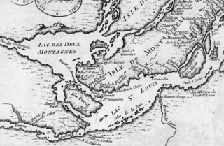
English: This is a detail of the original source map, cropped to depict the western part of the Isle of Montreal and immediately surrounding mainland as far as Les Cèdres. The map's caption reads "Montreal et ses Environs" (Montreal and its environs). It depicts a number of places relevant to the 1776 Battle of the Cedars. |
| 日期 | |
| 来源 | Bibliothèque Nationale de France http://gallica2.bnf.fr/ark:/12148/btv1b67001778 |
| 作者 | Bellin, Jacques-Nicolas, for the Kingdom of France |
| 其他版本 | IsleDeMontreal1764.png |
许可协议
|
本作品在其来源国以及其他著作权期限是作者逝世后100年或以下的国家和地区属于公有领域。 | |
| 本文件已被确认为免除已知的著作权法限制(包括所有相关权利)。 | |
文件历史
点击某个日期/时间查看对应时刻的文件。
| 日期/时间 | 缩略图 | 大小 | 用户 | 备注 | |
|---|---|---|---|---|---|
| 当前 | 2009年1月23日 (五) 22:57 | | 1,067 × 697(1.19 MB) | Magicpiano | {{Information |Description={{en|1=This is a detail of the original source map, cropped to depict the western part of the Isle of Montreal and immediately surrounding mainland as far as Les Cèdres. The map's caption reads "Montreal et ses Environs" (Mont |
文件用途
以下页面使用本文件:
全域文件用途
以下其他wiki使用此文件:
- ar.wikipedia.org上的用途
- en.wikipedia.org上的用途
- it.wikipedia.org上的用途
- ja.wikipedia.org上的用途
- nl.wikipedia.org上的用途
- www.wikidata.org上的用途