File:MountGriggs.jpg

本预览的尺寸:800 × 538像素。 其他分辨率:320 × 215像素 | 640 × 430像素 | 1,024 × 688像素。
原始文件 (1,024 × 688像素,文件大小:180 KB,MIME类型:image/jpeg)
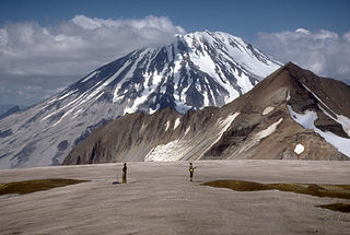
| 描述 | Mount Griggs volcano, 2,317-m (7,602 ft)-high, here seen from the west rim of Katmai caldera, lies 10 km (6 mi) behind the volcanic arc defined by other Katmai group volcanoes. Although no historic eruptions have been reported from Mount Griggs, vigorously active fumaroles persist in a summit crater and along the upper southwest flank. The slopes of Mount Griggs are heavily mantled by fallout from the 1912 eruption of Novarupta volcano. View is to the northwest. | |||
| 日期 | ||||
| 来源 | http://pubs.usgs.gov/dds/dds-40/ | |||
| 作者 | R. McGimsey, U.S. Geological Survey | |||
| 授权 (二次使用本文件) |
|
文件历史
点击某个日期/时间查看对应时刻的文件。
| 日期/时间 | 缩略图 | 大小 | 用户 | 备注 | |
|---|---|---|---|---|---|
| 当前 | 2005年1月20日 (四) 13:25 | | 1,024 × 688(180 KB) | GarciaB~commonswiki | Mount Griggs Volcano, Alaska |
文件用途
以下页面使用本文件:
全域文件用途
以下其他wiki使用此文件:
- arz.wikipedia.org上的用途
- ca.wikipedia.org上的用途
- ceb.wikipedia.org上的用途
- de.wikipedia.org上的用途
- en.wikipedia.org上的用途
- es.wikipedia.org上的用途
- fr.wikipedia.org上的用途
- ko.wikipedia.org上的用途
- lld.wikipedia.org上的用途
- ms.wikipedia.org上的用途
- no.wikipedia.org上的用途
- ru.wikipedia.org上的用途
- uk.wikipedia.org上的用途
- ur.wikipedia.org上的用途
- www.wikidata.org上的用途