File:NTSBSpuytenDuyvilDerailment2013.jpg
此为最大尺寸。
NTSBSpuytenDuyvilDerailment2013.jpg (800 × 484像素,文件大小:107 KB,MIME类型:image/jpeg)
摘要
| 描述 |
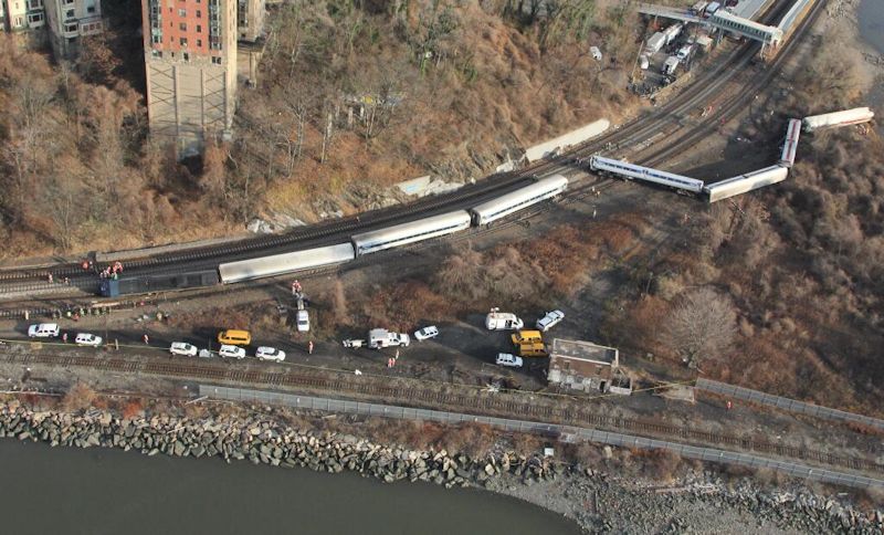
中文(简体):航拍斯派滕戴维尔火车脱轨事故现场 English: Aerial view of the December 2013 Spuyten Duyvil derailment. |
| 日期 | |
| 来源 | https://twitter.com/NTSB/status/407329136735027200/photo/1 |
| 作者 | National Transportation Safety Board |
| 相机位置 | | 在以下服务上查看本图像和附近其他图像: OpenStreetMap |
|---|
许可协议
原始上传日志
The original description page was here. All following user names refer to en.wikipedia.
- 22:42, December 1, 2013 Twinbros22 2048×1536× (1345862 bytes) {{Information |Description = Aerial view of the December 2013 Spuyten Duyvil derailment. |Source = http://twitter.com/NTSB/status/407329136735027200/photo/ |Date = ~~~~~ |Author = NTSB |other_versions = }}
文件历史
点击某个日期/时间查看对应时刻的文件。
| 日期/时间 | 缩略图 | 大小 | 用户 | 备注 | |
|---|---|---|---|---|---|
| 当前 | 2013年12月2日 (一) 08:40 | | 800 × 484(107 KB) | Qa003qa003 | User created page with UploadWizard |
文件用途
以下页面使用本文件:
全域文件用途
以下其他wiki使用此文件:
- de.wikipedia.org上的用途
- en.wikipedia.org上的用途
- List of rail accidents (2010–2019)
- Wikipedia:Recent additions/2013/December
- December 2013 Spuyten Duyvil derailment
- Template:Did you know nominations/December 2013 Spuyten Duyvil derailment
- Portal:Trains/Did you know/Main page, 2013
- User talk:Oceanflynn/sandbox/crude oil transportation (North America)
- Portal:Trains/Did you know/June 2017
- User talk:InedibleHulk/Archive 7
- fr.wikinews.org上的用途
- vi.wikipedia.org上的用途