File:Negroland and Guinea with the European Settlements, 1736.jpg

本预览的尺寸:800 × 596像素。 其他分辨率:320 × 238像素 | 640 × 477像素 | 1,024 × 763像素 | 1,200 × 894像素。
原始文件 (1,200 × 894像素,文件大小:1.55 MB,MIME类型:image/jpeg)
Map|thumb|alt=https://www.canva.com/design/DAEqyLnPwRY/share/preview?token=KSHUFcVdAgta6UUstYCF7w&role=EDITOR&utm_content=DAEqyLnPwRY&utm_campaign=designshare&utm_medium=link&utm_source=sharebutton%7CThis 1747 Map reflects the various Kingdoms. The Kingdom of Juda(h). Ouidah /ˈwiːdə/, also Whydah /ˈhwaɪdə/ ]]
摘要
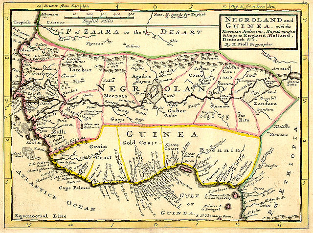
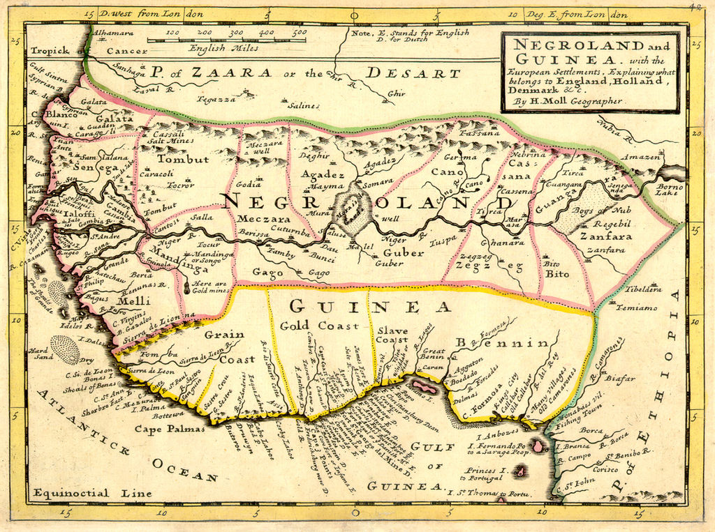
| 描述 | Full title: 'Negroland and Guinea with the European Settlements, Explaining what belongs to England, Holland, Denmark, etc'. By H. Moll Geographer (Printed and sold by T. Bowles next ye Chapter House in St. Pauls Church yard, & I. Bowles at ye Black Horse in Cornhill, 1729, orig. published in 1727). [1] |
| 日期 | |
| 来源 | University of Florida, George A. Smathers Libraries, historic African maps: 1729 Herman Moll (#ALW1663) |
| 作者 | Herman Moll |
许可协议
|
本作品在其来源国以及其他著作权期限是作者逝世后100年或以下的国家和地区属于公有领域。 | |
| 本文件已被确认为免除已知的著作权法限制(包括所有相关权利)。 | |
原始上传日志
(All user names refer to en.wikipedia)
- 2006-06-13 23:18 LIL T 1200×894×8 (1624023 bytes)
文件历史
点击某个日期/时间查看对应时刻的文件。
| 日期/时间 | 缩略图 | 大小 | 用户 | 备注 | |
|---|---|---|---|---|---|
| 当前 | 2008年2月3日 (日) 06:16 | | 1,200 × 894(1.55 MB) | BetacommandBot | move approved by: User:Dcoetzee This image was moved from Image:ALW1663L.jpg {{Information |Description=Full title: 'Negroland and Guinea with the European Settlements, Explaining what belongs to England, Holland, Denmark, etc'. By [[:en:Herman |
文件用途
全域文件用途
以下其他wiki使用此文件:
- an.wikipedia.org上的用途
- ar.wikipedia.org上的用途
- ba.wikipedia.org上的用途
- be.wikipedia.org上的用途
- bn.wikipedia.org上的用途
- br.wikipedia.org上的用途
- bs.wikipedia.org上的用途
- ca.wikipedia.org上的用途
- ceb.wikipedia.org上的用途
- cs.wikipedia.org上的用途
- cv.wikipedia.org上的用途
- da.wikipedia.org上的用途
- de.wikipedia.org上的用途
- en.wikipedia.org上的用途
- eo.wikipedia.org上的用途
- es.wikipedia.org上的用途
- eu.wikipedia.org上的用途
- fa.wikipedia.org上的用途
- fi.wikipedia.org上的用途
- fr.wikipedia.org上的用途
查看本文件的更多全域用途。