File:Nemegtomaia maps.png

本预览的尺寸:800 × 407像素。 其他分辨率:320 × 163像素 | 640 × 326像素 | 1,024 × 521像素 | 1,280 × 651像素 | 3,397 × 1,729像素。
原始文件 (3,397 × 1,729像素,文件大小:4.66 MB,MIME类型:image/png)
摘要
| 描述 |
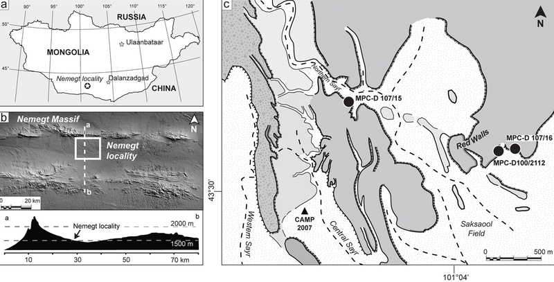
The Nemegt locality the Gobi Desert, southern Mongolia. A, map showing the location of the study area within southern Mongolia; B, the Nemegt area is located a few kilometers south of the massif of the same name; C, a detail of the Nemegt locality (sensu 5), showing the exact locations of Nemegtomaia specimens described in this study. |
| 日期 | |
| 来源 | http://www.plosone.org/article/info%3Adoi%2F10.1371%2Fjournal.pone.0031330 |
| 作者 | Federico Fanti, Philip J. Currie, Demchig Badamgarav |
许可协议
管理员或受信用户Dyolf77确认本图片在2016年3月30日可在下列站点找到并符合所选许可证:
http://www.plosone.org/article/info%3Adoi%2F10.1371%2Fjournal.pone.0031330 |
文件历史
点击某个日期/时间查看对应时刻的文件。
| 日期/时间 | 缩略图 | 大小 | 用户 | 备注 | |
|---|---|---|---|---|---|
| 当前 | 2018年10月24日 (三) 21:53 | | 3,397 × 1,729(4.66 MB) | FunkMonk | Cropped 1 % horizontally, 1 % vertically using CropTool with precise mode. |
| 2016年9月8日 (四) 22:35 |  | 3,446 × 1,753(4.72 MB) | FunkMonk | == {{int:filedesc}} == {{Information |Description=The Nemegt locality the Gobi Desert, southern Mongolia. A, map showing the location of the study area within southern Mongolia; B, the Nemegt area is located a few kilometers south of the massif of the... |
文件用途
以下页面使用本文件:
全域文件用途
以下其他wiki使用此文件:
- de.wikipedia.org上的用途
- en.wikipedia.org上的用途
- es.wikipedia.org上的用途
- fa.wikipedia.org上的用途
- nl.wikipedia.org上的用途
- pl.wikipedia.org上的用途