File:Obcine Slovenija 2006.svg

此SVG文件的PNG预览的大小:800 × 522像素。 其他分辨率:320 × 209像素 | 640 × 418像素 | 1,024 × 668像素 | 1,280 × 835像素 | 2,560 × 1,670像素 | 2,613 × 1,705像素。
原始文件 (SVG文件,尺寸为2,613 × 1,705像素,文件大小:2.31 MB)
摘要
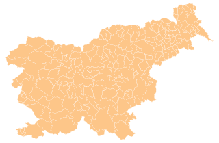
| 描述 | Map of the municipalities (občine) of the Republic of Slovenia, as since May 2006 (210 units). |
| 日期 | |
| 来源 | Source of the public data is GURS (Geodetska uprava Republike Slovenije or Surveying and Mapping Authority of the Republic of Slovenia). Converted from Shapefile to SVG with shp2svg and prepared for Wikipedia by romanm (talk). |
| 作者 | See above. |
| 授权 (二次使用本文件) |
See Pogoji uporabe (in Slovene) and Terms and conditions (English). According to price list, which states cost 0€ for using free-of-charge published data on municipalities even for commercial purposes(!), I consider the data to be in public domain. I also hereby grant my work on this file to be in public domain. |
| 其他版本 |
|

许可协议
| 我,本作品著作权人,释出本作品至公有领域。这适用于全世界。 在一些国家这可能不合法;如果是这样的话,那么: 我无条件地授予任何人以任何目的使用本作品的权利,除非这些条件是法律规定所必需的。 |
文件历史
点击某个日期/时间查看对应时刻的文件。
| 日期/时间 | 缩略图 | 大小 | 用户 | 备注 | |
|---|---|---|---|---|---|
| 当前 | 2012年4月13日 (五) 16:19 | | 2,613 × 1,705(2.31 MB) | Martin Kraft | size and display problem fixed reduced number of points |
| 2008年11月3日 (一) 21:32 |  | 2,613 × 1,705(2.36 MB) | Romanm | fixed aspect ratio Category:Maps of administrative units of Slovenia | |
| 2008年11月3日 (一) 21:21 |  | 512 × 334(2.36 MB) | Romanm | {{Information |Description=Map of the municipalities (''občine'') of the Republic of Slovenia, as since May 2006 (211 units). |Source=Source of [http://www.gu.gov.si/si/delovnapodrocja_gu/podatki_gu/brezplani_podatki/brezplani_podatki_obine/ the public d |
文件用途
没有页面使用本文件。
全域文件用途
以下其他wiki使用此文件:
- ast.wikipedia.org上的用途
- azb.wikipedia.org上的用途
- cs.wikipedia.org上的用途
- de.wikipedia.org上的用途
- eu.wikipedia.org上的用途
- kbd.wikipedia.org上的用途
- la.wikipedia.org上的用途
- sco.wikipedia.org上的用途
- sl.wikipedia.org上的用途
- vi.wikipedia.org上的用途