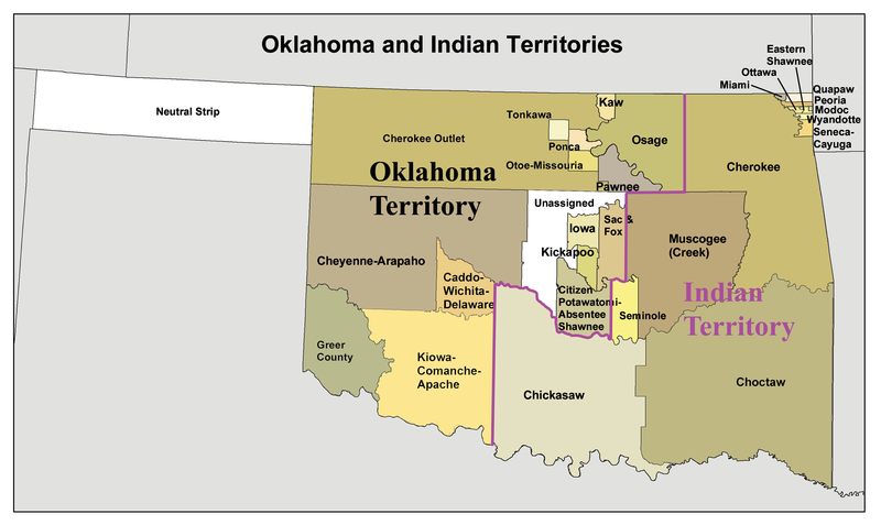
File:Okterritory.png

本预览的尺寸:800 × 477像素。 其他分辨率:320 × 191像素 | 640 × 382像素 | 1,024 × 611像素 | 1,280 × 763像素 | 2,515 × 1,500像素。
原始文件 (2,515 × 1,500像素,文件大小:534 KB,MIME类型:image/png)
文件历史
点击某个日期/时间查看对应时刻的文件。
| 日期/时间 | 缩略图 | 大小 | 用户 | 备注 | |
|---|---|---|---|---|---|
| 当前 | 2010年1月20日 (三) 16:34 |  | 2,515 × 1,500(534 KB) | Kmusser | spelling correction |
| 2010年1月20日 (三) 15:10 |  | 2,551 × 1,500(557 KB) | Kmusser | increased resolution | |
| 2006年7月31日 (一) 18:02 |  | 600 × 358(33 KB) | Kmusser | == Summary == This is a map of Oklahoma and Indian Territory circa 1890's that I made using and Census Bureau data and [http://hdl.loc.gov/loc.gmd/g4021e.ct000224 this |
文件用途
全域文件用途
以下其他wiki使用此文件:
- af.wikipedia.org上的用途
- ar.wikipedia.org上的用途
- arz.wikipedia.org上的用途
- bcl.wikipedia.org上的用途
- bn.wikipedia.org上的用途
- ca.wikipedia.org上的用途
- Osages
- Chickasaw (grup humà)
- Choctaws
- Wichita (poble)
- Tonkawes
- Caddos
- Comtat de Cimarron
- Comtat de Beaver (Oklahoma)
- Oklahoma Panhandle
- Cinc tribus civilitzades
- Apatxe kiowa
- Territori Indi
- Nació Chickasaw
- Plantilla:Territori Indi
- Nació Choctaw d'Oklahoma
- Districte Apukshunnubbee
- Districte Moshulatubbee
- Districte Pushmataha
- Nació Muscogee
- Estat de Sequoyah
- Nació Seminola d'Oklahoma
- Indian Intercourse Act
- Llei Orgànica d'Oklahoma
- chr.wikipedia.org上的用途
- chy.wikipedia.org上的用途
- cy.wikipedia.org上的用途
- de.wikipedia.org上的用途
查看此文件的更多全域用途。

