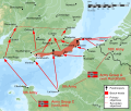
File:OperationSealion.svg

此SVG文件的PNG预览的大小:707 × 599像素。 其他分辨率:283 × 240像素 | 566 × 480像素 | 906 × 768像素 | 1,208 × 1,024像素 | 2,416 × 2,048像素 | 5,277 × 4,473像素。
原始文件 (SVG文件,尺寸为5,277 × 4,473像素,文件大小:2.04 MB)
文件历史
点击某个日期/时间查看对应时刻的文件。
| 日期/时间 | 缩略图 | 大小 | 用户 | 备注 | |
|---|---|---|---|---|---|
| 当前 | 2013年3月19日 (二) 19:06 |  | 5,277 × 4,473(2.04 MB) | Hel-hama | text quality improved |
| 2009年4月2日 (四) 00:30 |  | 5,277 × 4,473(1.66 MB) | Wereon | trying version without shadow relief | |
| 2009年4月1日 (三) 22:58 |  | 5,277 × 4,473(3.46 MB) | Wereon | removed Inkscape cruft | |
| 2009年4月1日 (三) 19:20 |  | 5,277 × 4,473(3.56 MB) | Wereon | . <!--{{ImageUpload|basic}}--> |
文件用途
以下页面使用本文件:
全域文件用途
以下其他wiki使用此文件:
- ar.wikipedia.org上的用途
- be.wikipedia.org上的用途
- br.wikipedia.org上的用途
- cs.wikipedia.org上的用途
- el.wikipedia.org上的用途
- en.wikipedia.org上的用途
- en.wikibooks.org上的用途
- eu.wikipedia.org上的用途
- fa.wikipedia.org上的用途
- he.wikipedia.org上的用途
- id.wikipedia.org上的用途
- it.wikiquote.org上的用途
- ja.wikipedia.org上的用途
- ko.wikipedia.org上的用途
- no.wikipedia.org上的用途
- pl.wikipedia.org上的用途
- ro.wikipedia.org上的用途
- ru.wikipedia.org上的用途
- simple.wikipedia.org上的用途
- sk.wikipedia.org上的用途
- sv.wikipedia.org上的用途
- ta.wikipedia.org上的用途
- th.wikipedia.org上的用途
- tr.wikipedia.org上的用途
- uk.wikipedia.org上的用途
- vi.wikipedia.org上的用途
- www.wikidata.org上的用途


