File:Paris Metro Ligne 1.svg

此SVG文件的PNG预览的大小:512 × 197像素。 其他分辨率:320 × 123像素 | 640 × 246像素 | 1,024 × 394像素 | 1,280 × 493像素 | 2,560 × 985像素。
原始文件 (SVG文件,尺寸为512 × 197像素,文件大小:13 KB)
摘要
| 描述 |
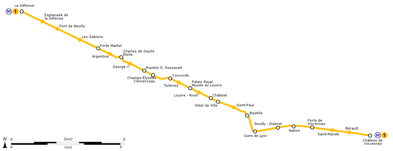
English: Geographically accurate path of Paris Métro Line 1. Français : Plan géographique de la ligne 1 du métro de Paris. |
||
| 日期 | (UTC) | ||
| 来源 | File:Ligne 1.gif by Metropolitan under licence Public Domain | ||
| 作者 | Sémhur (留言) | ||
| 其他版本 | |||
| SVG |
|
||
| Graphic Lab |

| 物体位置 | | 在以下服务上查看本图像和附近其他图像: OpenStreetMap |
|---|
许可协议
我,本作品著作权人,特此采用以下许可协议发表本作品:
| 本作品采用知识共享CC0 1.0 通用公有领域贡献许可协议授权。 | |
| 采用本宣告发表本作品的人,已在法律允许的范围内,通过在全世界放弃其对本作品拥有的著作权法规定的所有权利(包括所有相关权利),将本作品贡献至公有领域。您可以复制、修改、传播和表演本作品,将其用于商业目的,无需要求授权。
|
文件历史
点击某个日期/时间查看对应时刻的文件。
| 日期/时间 | 缩略图 | 大小 | 用户 | 备注 | |
|---|---|---|---|---|---|
| 当前 | 2020年7月17日 (五) 17:53 | 512 × 197(13 KB) | Teo.raff | Metro and line icons and colours update | |
| 2018年10月12日 (五) 23:21 | 2,166 × 834(40 KB) | AlexBurn44 | corres | ||
| 2015年3月13日 (五) 12:14 | 2,166 × 834(41 KB) | Sémhur | REmove black line | ||
| 2014年12月28日 (日) 16:47 | 2,166 × 834(37 KB) | Sémhur | == {{int:filedesc}} == {{Information |Description={{Multilingual description |en= Geographically accurate path of en:Paris Métro Line 1. |fr= Plan géographique de la fr:ligne 1 du métro de Paris. }} |Source=File:Ligne 1.gif by [[:en... |
文件用途
以下页面使用本文件:
全域文件用途
以下其他wiki使用此文件:
- bs.wikipedia.org上的用途
- cs.wikipedia.org上的用途
- dsb.wikipedia.org上的用途
- en.wikipedia.org上的用途
- eo.wikipedia.org上的用途
- es.wikipedia.org上的用途
- fr.wikipedia.org上的用途
- it.wikipedia.org上的用途
- ja.wikipedia.org上的用途
- ko.wikipedia.org上的用途
- lb.wikipedia.org上的用途
- nl.wikipedia.org上的用途
- no.wikipedia.org上的用途
- oc.wikipedia.org上的用途
- pl.wikipedia.org上的用途
- ru.wikipedia.org上的用途
- sk.wikipedia.org上的用途
- tr.wikipedia.org上的用途
- uk.wikipedia.org上的用途
- zh-min-nan.wikipedia.org上的用途