File:Prima Europe tabula.jpg

本预览的尺寸:800 × 572像素。 其他分辨率:320 × 229像素 | 640 × 458像素 | 1,024 × 733像素 | 1,280 × 916像素 | 2,560 × 1,832像素 | 6,000 × 4,293像素。
原始文件 (6,000 × 4,293像素,文件大小:9.63 MB,MIME类型:image/jpeg)
摘要
| 克劳狄乌斯·托勒密:Prima Europe Tabula
|
|||||
|---|---|---|---|---|---|
| 艺术家 |  | ||||
| 标题 |
Prima Europe tabula |
||||
| 所属实体 |
地理学指南 |
||||
| 物体类型 |
地图 |
||||
| 描述 |
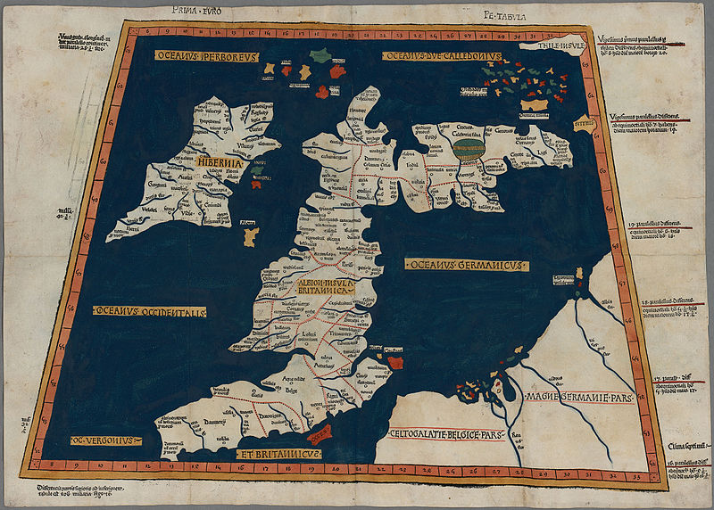
One of the earliest surviving copies of Ptolemy's 2nd century map of the British Isles. Originally published in Ptolemy's Geographia. This is the second issue of the 1482 map, also printed at Ulm, which was the first woodcut map of the British Isles and the first to be printed outside Italy. |
||||
| 日期 | 1486年 | ||||
| 尺寸 | 高度:350毫米;宽度:500毫米 | ||||
| 馆藏 | |||||
| 备注 | Scale not given | ||||
| 来源/摄影师 |
|
||||
| 授权 (二次使用本文件) |
|
||||


文件历史
点击某个日期/时间查看对应时刻的文件。
| 日期/时间 | 缩略图 | 大小 | 用户 | 备注 | |
|---|---|---|---|---|---|
| 当前 | 2015年10月21日 (三) 13:01 | | 6,000 × 4,293(9.63 MB) | Jason.nlw | User created page with UploadWizard |
文件用途
以下页面使用本文件:
全域文件用途
以下其他wiki使用此文件:
- ar.wikipedia.org上的用途
- cy.wikipedia.org上的用途
- da.wikipedia.org上的用途
- de.wikipedia.org上的用途
- el.wikipedia.org上的用途
- en.wikipedia.org上的用途
- es.wikipedia.org上的用途
- et.wikipedia.org上的用途
- hr.wikipedia.org上的用途
- it.wikipedia.org上的用途
- www.wikidata.org上的用途