File:Senpoku shingojo ato.jpg

本预览的尺寸:600 × 600像素。 其他分辨率:240 × 240像素 | 480 × 480像素 | 969 × 969像素。
原始文件 (969 × 969像素,文件大小:873 KB,MIME类型:image/jpeg)
摘要
| 描述 |
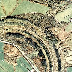
日本語: 網走本線(後の池北線) 釧北信号場/仮乗降場跡 1977年。周囲約1km範囲。左が置戸方面、下が小利別方面。丁度カーブの中間に信号場が設けられた。カーブの外側にうっすらとレール跡状のものが残っているが、この辺りは築堤と路盤跡が広く取られており、複線の構内があった名残がある。その外側の植林された林の辺りに官舎があった。置戸方に青い屋根の保線車両車庫と思われる建家と引込線が見える。 English: Abashiri Main Line (later Ikekita Line) Kushiro Kita Signal Station / Temporary Boarding Station Ruins 1977. The circumference range is about 1 km. On the left is the direction of Okito, and the bottom is the direction of Koribetsu. A signal station was set up just in the middle of the curve. There are still faint rail traces on the outside of the curve, but the embankment and roadbed traces are widely taken around here, and there are remnants of the double track premises. There was a government building around the planted forest outside it. You can see a building and a pull-in line that seems to be a car garage with a blue roof on the side of the door. |
| 日期 | |
| 来源 | 国土交通省 国土画像情報(カラー空中写真)を基に作成 |
| 作者 | Nisanyongo |
| 授权 (二次使用本文件) |
下記を参照して下さい |
许可协议

|
本文件的著作权人,國土交通省,允许任何人在适当地表明著作权人的姓名的前提下,以任何目的使用本文件。传播,演绎作品,商业用途及所有其他用途被允许。 |
署名:
Copyright © 地图/航拍图浏览服务 国土地理院
|
 |
此图像的版权归日本地理空间信息管理局所有。请参阅地图/航空照片查看服务使用条款和来自国土交通省的消息和旅游使用条款......。当您在文章上显示此图像时,请在说明中包含以下短语:“基于[https://mapps.gsi.go.jp/maplibSearch.do#1 National Land Image Information (颜色航拍照片)],国土交通省”。
|
文件历史
点击某个日期/时间查看对应时刻的文件。
| 日期/时间 | 缩略图 | 大小 | 用户 | 备注 | |
|---|---|---|---|---|---|
| 当前 | 2013年9月2日 (一) 14:19 | | 969 × 969(873 KB) | Nisanyongo | {{Information |Description=網走本線(後の池北線) 釧北信号場/仮乗降場跡 1977年。周囲約1km範囲。左が置戸方面、下が小利別方面。丁度カーブの中間に信号場が設けられた。カーブの外側に... |
文件用途
以下页面使用本文件:
全域文件用途
以下其他wiki使用此文件:
- ja.wikipedia.org上的用途