File:Southern Leyte mudslide 2006 pic01.jpg
本预览的尺寸:800 × 531像素。 其他分辨率:320 × 212像素 | 640 × 425像素 | 1,024 × 680像素 | 1,280 × 850像素 | 2,560 × 1,700像素 | 3,225 × 2,141像素。
原始文件 (3,225 × 2,141像素,文件大小:4.61 MB,MIME类型:image/jpeg)
| 描述 |
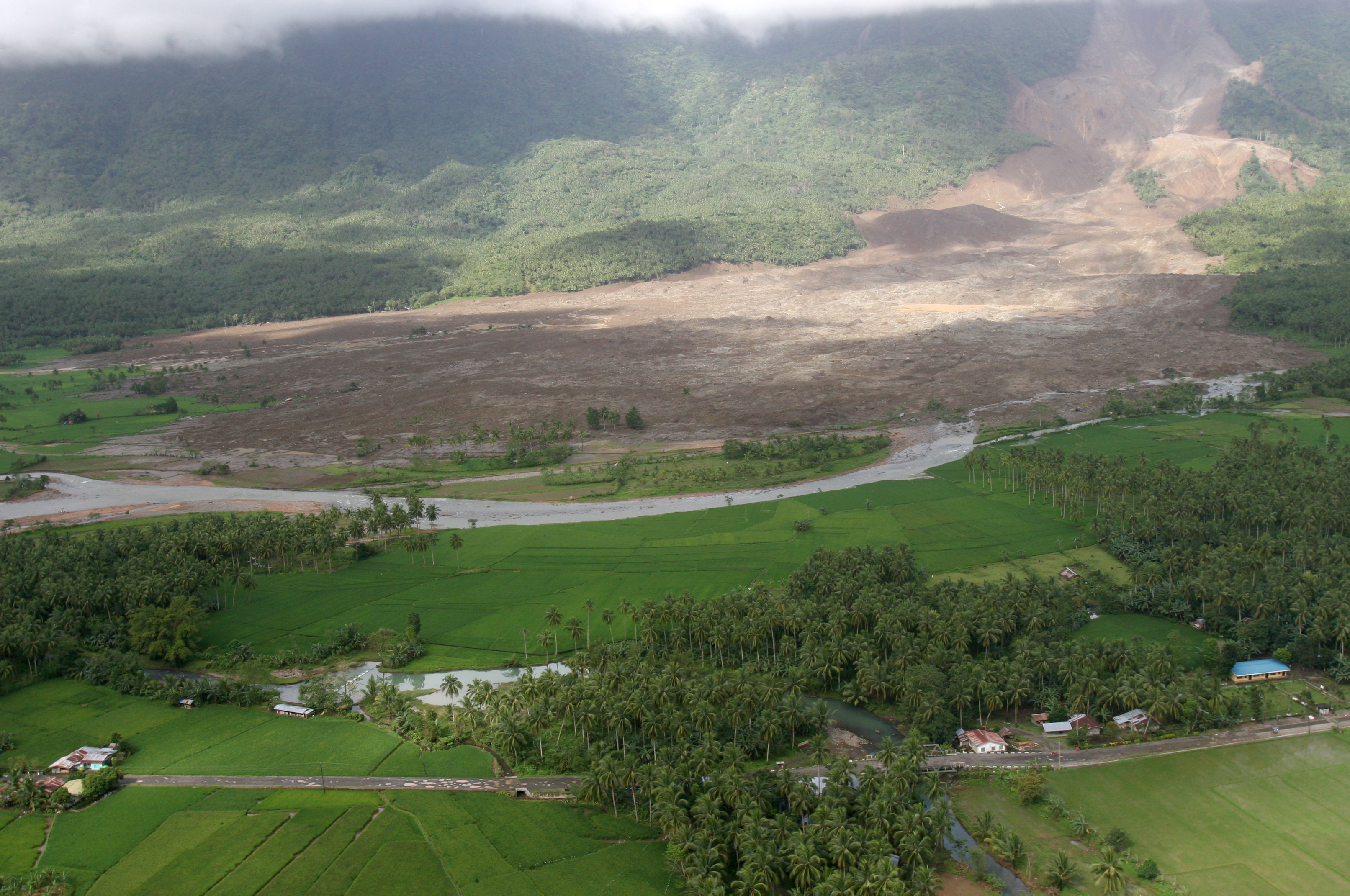
English: 060219-M-8084P-001 Saint Bernard, Republic of the Philippines (Feb. 19, 2006) - An aerial view of the mudslide, which destroyed the town of Guinsahugon the morning of Feb. 17. Guinsahugon is located in the southern part of the island of Leyte in the Philippines. The photo was taken from a CH-46E Sea Knight which was being flown to Guinsahugon to deliver relief supplies. The helicopter is from the 31st Marine Expeditionary Unit's aviation combat element Marine Medium Helicopter Squadron 262 (Reinforced). The MEU, based out of Okinawa, Japan, is deployed to the Philippines as part of the Forward Deployed Amphibious Ready Group (ARG) based out of Sasebo, Japan and was in the Philippines to take part in exercise Balikatan 2006 before responding to a request for aid by the Philippine government. U.S. Marine Corps photo by Lance Cpl. Raymond D. Petersen III (RELEASED)
Deutsch: Schlammlawine |
||||||
| 日期 | |||||||
| 来源 | http://www.navy.mil/view_image.asp?id=32089 | ||||||
| 作者 | Raymond D. Petersen III | ||||||
| 授权 (二次使用本文件) |
|
||||||

文件历史
点击某个日期/时间查看对应时刻的文件。
| 日期/时间 | 缩略图 | 大小 | 用户 | 备注 | |
|---|---|---|---|---|---|
| 当前 | 2006年2月20日 (一) 12:42 | | 3,225 × 2,141(4.61 MB) | Stefan Kühn | {{PD-USGov-Military-Navy}} Source: http://www.navy.mil/view_single.asp?id=32089 060219-M-8084P-001 Saint Bernard, Republic of the Philippines (Feb. 19, 2006) - An aerial view of the mudslide, which destroyed the town of Guinsahugon the morning of Feb. 1 |
文件用途
以下2个页面使用本文件:
全域文件用途
以下其他wiki使用此文件:
- ceb.wikipedia.org上的用途
- de.wikipedia.org上的用途
- en.wikipedia.org上的用途
- es.wikipedia.org上的用途
- fi.wikipedia.org上的用途
- fr.wikipedia.org上的用途
- hi.wikipedia.org上的用途
- id.wikipedia.org上的用途
- it.wikipedia.org上的用途
- ja.wikipedia.org上的用途
- ka.wikipedia.org上的用途
- mk.wikipedia.org上的用途
- ru.wikipedia.org上的用途
- sv.wikipedia.org上的用途
- tl.wikipedia.org上的用途
- zh-classical.wikipedia.org上的用途
- zh-min-nan.wikipedia.org上的用途