File:Sunset crater Landsat 2016.jpg
此为最大尺寸。
Sunset_crater_Landsat_2016.jpg (720 × 480像素,文件大小:182 KB,MIME类型:image/jpeg)
| 描述 |
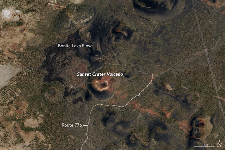
English: On July 12, 2016, the Operational Land Imager (OLI) on the Landsat 8 satellite captured a natural-color image (above) of the crater and the surrounding San Francisco Volcanic Field. The image was draped over terrain data from the Advanced Spaceborne Thermal Emission and Reflection Radiometer (ASTER). Note: the scene was rotated to create this image, so north is to the right. The closeup below shows Sunset Crater as observed by OLI, but without the terrain drape (north is up). To the east of the cone, a field of dark, hardened rock from the Bonita Lava Flow is still visible. |
|||||
| 日期 | acquired July 12, 2016 | |||||
| 来源 | https://earthobservatory.nasa.gov/IOTD/view.php?id=90413&src=eoa-iotd | |||||
| 作者 | NASA Earth Observatory images by Jesse Allen, using Landsat data from the U.S. Geological Survey | |||||
| 授权 (二次使用本文件) |
|

文件历史
点击某个日期/时间查看对应时刻的文件。
| 日期/时间 | 缩略图 | 大小 | 用户 | 备注 | |
|---|---|---|---|---|---|
| 当前 | 2017年7月26日 (三) 15:42 | | 720 × 480(182 KB) | Tillman | {{Information |Description ={{en|1=On July 12, 2016, the Operational Land Imager (OLI) on the Landsat 8 satellite captured a natural-color image (above) of the crater and the surrounding San Francisco Volcanic Field. The image was draped over terrai... |
文件用途
以下页面使用本文件: