File:Tupaia's map, c. 1769.jpg

本预览的尺寸:800 × 538像素。 其他分辨率:320 × 215像素 | 640 × 430像素 | 1,024 × 688像素 | 1,280 × 860像素 | 2,560 × 1,720像素 | 7,657 × 5,145像素。
原始文件 (7,657 × 5,145像素,文件大小:15.67 MB,MIME类型:image/jpeg)
摘要
| 艺术家 |
James Cook |
| 描述 |
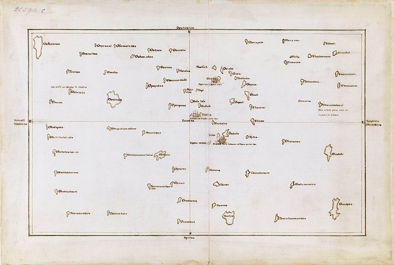
English: Tupaia's chart of the islands surrounding Tahiti in Oceania |
| 日期 | 约1769年 |
| 登录号 |
Add MS 21593 C |
| 参考 | The Society Islands |
| 来源/摄影师 |
British Library, London. |
许可协议
|
这是一个平面公有领域艺术品的忠实摄影副本。原艺术品本身因为下列原因属于公有领域:
维基媒体基金会的官方立场认为:“对平面公有领域艺术品的忠实再制作品也属于公有领域。”
因此,可以认为此摄影副本在美国也属于公有领域。在其他司法管辖区,再利用此内容可能存在限制;参见再利用PD-Art照片了解详细信息。 | ||||
文件历史
点击某个日期/时间查看对应时刻的文件。
| 日期/时间 | 缩略图 | 大小 | 用户 | 备注 | |
|---|---|---|---|---|---|
| 当前 | 2021年9月23日 (四) 02:03 | | 7,657 × 5,145(15.67 MB) | Capmo | Cropped 4 % horizontally, 6 % vertically using CropTool with lossless mode. |
| 2019年12月7日 (六) 00:15 |  | 8,000 × 5,484(15.06 MB) | Adjutor | Newer image from the British Library https://www.bl.uk/collection-items/the-society-islands accessed 07 December 2019. Format - Pen and Ink, Map; Creator - James Cook, Tupaia Add. MS 21593 C; Created 1769 "This is a view of the Society Islands by Captain James Cook, who completed his first exploration of the Pacific Ocean from 1769 to 1771. The chart is a copy of an original document by Tupaia, a priest and leader of the island of Ra’iatea. He was enlisted by Cook to navigate HMS Endeavour to... | |
| 2017年3月16日 (四) 02:50 |  | 1,600 × 975(371 KB) | KAVEBEAR | ||
| 2017年3月16日 (四) 02:46 |  | 801 × 488(84 KB) | KAVEBEAR |
文件用途
以下页面使用本文件:
全域文件用途
以下其他wiki使用此文件:
- de.wikipedia.org上的用途
- en.wikipedia.org上的用途
- es.wikipedia.org上的用途
- fa.wikipedia.org上的用途
- id.wikipedia.org上的用途
- it.wikipedia.org上的用途
- no.wikipedia.org上的用途